 Search: Bureau
Search: of
Filter: Categories of Wisconsin Historical Images
Filter: Subject of indian reservations
Search: Bureau
Search: of
Filter: Categories of Wisconsin Historical Images
Filter: Subject of indian reservations

| Date: | 1939 |
|---|---|
| Description: | This nine-part map from the U.S. Bureau of Public Roads identifies federal and state highways in Wisconsin by pavement type. County, forest, park, and publ... |

| Date: | 1941 |
|---|---|
| Description: | Wisconsin counties, towns, cities, and selected villages, as well as the Menominee Indian Reservation are identified on this U.S. Bureau of the Census map ... |
| Date: | |
|---|---|
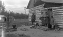
| Description: | Medicine man John King, his wife, grandchild, and family on the Lake Courte Oreilles Chippewa reservation near Couderay. |

| Date: | 1944 |
|---|---|
| Description: | This nine-part map from the U.S. Bureau of Public Roads identifies federal and state highways in Wisconsin by pavement type. County, forest, park, and publ... |

| Date: | 1940 |
|---|---|
| Description: | This blue line print map traced from aerial survey mosaic shows reservation boundary, roads, trails, and railroads. Color manuscript annotations show triba... |

| Date: | 1950 |
|---|---|
| Description: | This road map shows federal, state and county roads in Wisconsin, northern Illinois, northeastern Iowa, eastern Minnesota, and the western portion of Michi... |
If you didn't find the material you searched for, our Library Reference Staff can help.
Call our reference desk at 608-264-6535 or email us at: