 Filter: Year of 1900-1999
Filter: Community of Oneida
Filter: Year of 1900-1999
Filter: Community of Oneida
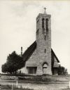
| Date: | 1900 |
|---|---|
| Description: | Hobart Episcopal Church on the Oneida Indian Reservation. |

| Date: | 1908 |
|---|---|
| Description: | This 1908 map shows the township and range grid, sections, towns, villages, railroads, bridges, lakes, streams, rapids, and state-owned lands in Oneida Cou... |

| Date: | 1959 |
|---|---|
| Description: | This map identifies public forest land and industrial forest land as of 1959 in Oneida County, Wisconsin, using a 1930 base map showing the township and ra... |

| Date: | 1930 |
|---|---|
| Description: | These 40 hand-drawn maps depict the survey townships in Oneida County, Wisconsin, on printed township grids. Lakes, rivers, and waterfront properties are d... |
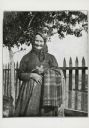
| Date: | 1909 |
|---|---|
| Description: | Portrait of a woman, who is wearing a dress and a kerchief knotted around her hair. She is holding some cloth over her arm, and an unidentified object in h... |
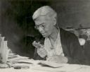
| Date: | 1949 |
|---|---|
| Description: | Portrait of Dr. Lillie Rosa Minoka Hill, a physician of Mohawk ancestry. She is sitting at a table examining a book through a magnifying glass. Dr. Minoka ... |
If you didn't find the material you searched for, our Library Reference Staff can help.
Call our reference desk at 608-264-6535 or email us at: