Filter: Year of 1800-1899
Filter: Year of 1810-1819
Filter: Year of 1800-1899
Filter: Year of 1810-1819
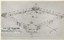
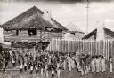
| Date: | 1817 |
|---|---|
| Description: | Elevated view of Old Fort Crawford. Caption reads: "Log Fort Crawford 1816-1829 Sketch Made From, Maj. S.H. Long's Description of 1817." |
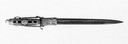
| Date: | 1812 |
|---|---|
| Description: | Dagger from an American officer of the war of 1812. Renat was a member of the naval fleet of the Great Lakes which was under the command Oliver Hazard Perr... |
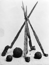
| Date: | 1812 |
|---|---|
| Description: | Four rusted bayonets and shot that sat in the hold of the ship Niagara for 80 years. |

| Date: | 1814 |
|---|---|
| Description: | Map of the Upper Territories of the United States. |

| Date: | 1813 |
|---|---|
| Description: | Eastern half of the United States. Scale: 2.5 inches = 250 miles. |

| Date: | 1814 |
|---|---|
| Description: | Scale: about 43 miles to 1 in. Boundaries colored. |
| Date: | 1814 |
|---|---|
| Description: | Fort Shelby built in 1814 and named for the Governor of Kentucky, was surrendered to British forces later in 1814 and renamed Fort McKay. Pictured here is ... |

| Date: | 1814 |
|---|---|
| Description: | Fort Shelby, built by the Americans during the War of 1812. In 1814 the fort surrendered to British forces led by Captain Andrew W. Bulger who renamed it F... |
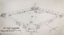
| Date: | 1817 |
|---|---|
| Description: | Sketch of an elevated view of Fort Crawford (1816-1829). |
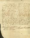
| Date: | 1812 |
|---|---|
| Description: | A contract, written by Joseph Grubb regarding work and boarding for Samuel Marshall, which is signed by Grubb. |
| Date: | 03 14 1812 |
|---|---|
| Description: | English translation of the Fur Trade Engagement for Charles St. Antoine dit Vacher. |
| Date: | 03 14 1812 |
|---|---|
| Description: | A fur trade engagement for Charles St. Antoine dit Vacher, written in French. |
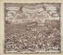
| Date: | 1819 |
|---|---|
| Description: | A commemorative handkerchief created by a wood engraving on white cotton fabric. The scene is the Manchester Reform Meeting, in England. A crowd of demonst... |

| Date: | 10 08 1811 |
|---|---|
| Description: | A handbill entitled "McKinley, The Poltroon & Assassin, In His True Colors." |

| Date: | 1816 |
|---|---|
| Description: | This is a photostat copy of a manuscript map in the National Archives showing a plan of Fort Howard and a view of its north side. Originally surveyed by Wi... |
| Date: | 08 27 1814 |
|---|---|
| Description: | Newspaper article on the "Capture and Destruction of the Capital" relating information on the burning of Washington, D.C. on August 24, 1814. The city was ... |
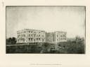
| Date: | 1814 |
|---|---|
| Description: | Exterior view of the U.S. Capitol building after the fire in August. The Federal building was burned by British forces during the War of 1812. In the foreg... |
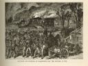
| Date: | 1814 |
|---|---|
| Description: | Etching depicting the burning of Washington, D.C. by the British during the War of 1812. In the foreground are a number of soldiers moving toward the Capit... |
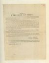
| Date: | 07 02 1813 |
|---|---|
| Description: | A handbill circulated by Governor Meigs and General McArthur of Ohio in an effort to recruit men into the local militia. Men were needed to serve against t... |
If you didn't find the material you searched for, our Library Reference Staff can help.
Call our reference desk at 608-264-6535 or email us at: