 Filter: Subject of architecture
Filter: Type of Map or Atlas
Filter: County of Milwaukee
Filter: Subject of architecture
Filter: Type of Map or Atlas
Filter: County of Milwaukee

| Date: | 1856 |
|---|---|
| Description: | View looking west from Lake Michigan with several steam ships and sailing vessels in harbor. There is a lighthouse to left of center, along shoreline. |

| Date: | 1882 |
|---|---|
| Description: | Bird's-eye views of various sections of Milwaukee. |

| Date: | 1898 |
|---|---|
| Description: | Bird's-eye map of Milwaukee with prominent streets and buildings identified. Taken from City Hall Tower. |

| Date: | 1858 |
|---|---|
| Description: | An ink on paper map of Milwaukee County and the eastern portion of Waukesha County that shows the townships of Oak Creek, Franklin, Greenfield, Wauwatosa, ... |

| Date: | 1886 |
|---|---|
| Description: | A hand-colored map of Milwaukee County, Wisconsin that shows the township and range system, sections, towns, roads, railroads and rail stations, cities and... |

| Date: | 1891 |
|---|---|
| Description: | A hand-colored map of Milwaukee County, Wisconsin that shows the township and range system, sections, towns, roads, railroads and rail stations, cities and... |

| Date: | 1896 |
|---|---|
| Description: | A map of Milwaukee County, Wisconsin that shows the township and range system, sections, towns, roads, railroads and rail stations, cities and villages, po... |

| Date: | 1902 |
|---|---|
| Description: | A map of Milwaukee County, Wisconsin that shows the township and range system, sections, towns, roads, railroads and rail stations, cities and villages, po... |

| Date: | 1863 |
|---|---|
| Description: | Includes index to public buildings, churches, schools. Inset: Glidden & Lockwood’s addition. Gives names of some property owners. |

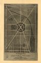
| Date: | 05 1958 |
|---|---|
| Description: | Photocopy of a map created by the City of Milwaukee Master Plan Program City Planning Division in May of 1958 representing 1870 "THE CENTRAL AREA OF THE CI... |

| Date: | 1880 |
|---|---|
| Description: | Map created from original drawing and surveys taken by Silas Chapman. Bottom right corner features a reference key. There is a street guide on the left sid... |

| Date: | 1891 |
|---|---|
| Description: | This maps has an index of depots, hotels, prominent institutions and buildings, churches, and places of amusement. The map was removed from an unidentified... |

| Date: | 1886 |
|---|---|
| Description: | Map shows townships, post offices, roads, railroads, and selected buildings. The sections are in pink, green, blue, and yellow. Counties, towns, and lakes ... |

| Date: | 1903 |
|---|---|
| Description: | Map shows railroads, roads, street car lines, schools, churches, cemeteries, town halls, and railroad stations. Includes inset lists of: Population of Milw... |
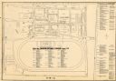
| Date: | 1948 |
|---|---|
| Description: | This map of the Wisconsin Centennial Exposition is oriented with north to the right. The right hand margin includes "Outstanding Events of the Grandstand P... |
| Date: | 1974 |
|---|---|
| Description: | This map of Milwaukee shows forty landmark buildings located and identified, including those on the National Register of Historic Places and the Historic A... |

| Date: | 1960 |
|---|---|
| Description: | This map of Greedale shows local streets, parks, schools, and churches and includes manuscript annotations in green and blue showing tracts and parcels of ... |
| Date: | 1930 |
|---|---|
| Description: | This map of Granville shows local streets, local businesses, and industrial areas. Some streets are labeled: "Lovers Lane Road," "Granville Road," and "Bro... |

| Date: | 1932 |
|---|---|
| Description: | This map of Granville shows streets, businesses, residential areas, schools, golf courses, and industrial areas. The map shows Granville in March of 1932. ... |

| Date: | 1938 |
|---|---|
| Description: | This map shows buildings, lots, parks, schools, pumping stations, sites reserved for churches, and water towers. |
If you didn't find the material you searched for, our Library Reference Staff can help.
Call our reference desk at 608-264-6535 or email us at: