 Filter: Subject of Sauk Indians

| Date: | 1998 |
|---|---|
| Description: | This map shows an auto tour route with historical markers and the approximate Black Hawk Band route in southern Wisconsin. County boundaries, roads and cit... |
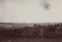
| Date: | 08 1898 |
|---|---|
| Description: | Caption reads: "View from N.E. 1/4 of S.E. 1/4 Sec. 36 L. 12 R 7 W. looking toward Victory, Vernon Co. Wis., showing last 4 miles of trail of Atkinson's Ar... |
If you didn't find the material you searched for, our Library Reference Staff can help.
Call our reference desk at 608-264-6535 or email us at: