Filter: Subject of Ocean
Filter: Year of 1800-1899
Filter: Subject of Ocean
Filter: Year of 1800-1899
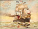
| Date: | 1897 |
|---|---|
| Description: | Color lithograph cover illustration for the McCormick Harvesting Machine Company catalog. Shows a steam powered sailing ship named "Progress" with a McCorm... |

| Date: | 1883 |
|---|---|
| Description: | Engraving of a woman carrying a bundle of clothing and standing with her back to the sea. Behind her other women are in the process of doing wash in the wa... |

| Date: | 1893 |
|---|---|
| Description: | Front and back covers of an advertising brochure for the New Empire line of mowers, reapers and grain binders manufactured by J.F. Seiberling & Company. Th... |

| Date: | 1886 |
|---|---|
| Description: | Advertisement for the Atchison, Topeka and Santa Fe Railroad featuring an illustration of Uncle Sam stretched from the Missouri River to the Pacific Ocean.... |

| Date: | 1831 |
|---|---|
| Description: | Map of the United States "constructed from the latest authorities," including a statistical table. |
| Date: | 1856 |
|---|---|
| Description: | At the beginning of his journey to America, Hölzlhuber passed through the English Channel and viewed the cliffs at Dover. "We passed Beachy Head, as this p... |

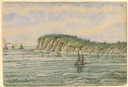
| Date: | 1856 |
|---|---|
| Description: | While passing through the English Channel in May 1856 Hölzlhuber viewed the Isle of Wight. "The island is located in the English Channel not far from Hamps... |
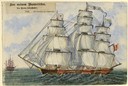
| Date: | 1856 |
|---|---|
| Description: | The Tuisco left Bremerhaven May 6, 1856. Hölzlhuber called this the "quickest three masted immigration boat," holding 335 passengers. Though in the ... |

| Date: | 1877 |
|---|---|
| Description: | Map showing location of Indian reservations in the United States and population figures. |

| Date: | 1804 |
|---|---|
| Description: | A map of Lewis and Clark's Track across the western portion of North America from the Mississippi River to the Pacific Ocean by order of the Executive of t... |

| Date: | 1857 |
|---|---|
| Description: | Information depicting the history, condition and prospects of the Indian tribes of the United States: collected and prepared under the direction of the Bur... |

| Date: | 1813 |
|---|---|
| Description: | Eastern half of the United States. Scale: 2.5 inches = 250 miles. |

| Date: | 1850 |
|---|---|
| Description: | [... through northern United States from New York to Minnesota]. Lithography by T. Sinclair. From Perrault papers, Lucien S. Hanks, donor. |

| Date: | 1824 |
|---|---|
| Description: | Drawn and engraved by Sidney Hall. Published by Longman, Hurst, Rees, Orme, Brown & Green. Scale: 1:200. Partly colored. This is probably the second Europe... |

| Date: | 1835 |
|---|---|
| Description: | Map reads: "Map of the United States of America with its Territories and Districts - Including also a part of Upper and Lower Canada and Mexico". The map i... |
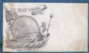
| Date: | 1860 |
|---|---|
| Description: | A Union sailor and King Neptune stand inside a sea shell that is floating on the ocean. Between them appears a decorative circle with the Union Armada in i... |
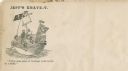
| Date: | 1860 |
|---|---|
| Description: | Jefferson Davis and six sailors sail in a tea cup. A pirate flag flies overhead. One sailor is in the "crow's nest." Another is using a paddle. Three sailo... |
If you didn't find the material you searched for, our Library Reference Staff can help.
Call our reference desk at 608-264-6535 or email us at: