Filter: Subject of Mississippi River
Filter: Year of 1800-1899
Filter: Subject of Mississippi River
Filter: Year of 1800-1899

| Date: | 1814 |
|---|---|
| Description: | Map of the Upper Territories of the United States. |
| Date: | 04 1862 |
|---|---|
| Description: | Notes include: Sketch of Battle of Island #10. Sketch of Fort Pillow Tennessee. Gen. Pope had command of the land troops. |
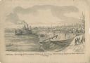
| Date: | 05 1862 |
|---|---|
| Description: | "Hamburg Landing, 4 miles below Pittsburg Landing, Commisary [sic] Depot of Gen. Hallek's Army." An encampment with soldiers along the river with a ... |

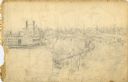
| Date: | 1862 |
|---|---|
| Description: | An image from a sketchbook of "The Gunboats at No. 10 — Eve of Arrival before the I'sld". The drawing appears to be from the deck of a ship showing several... |
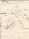
| Date: | 1862 |
|---|---|
| Description: | This is the preliminary sketch for "Hamburg Landing, 4 miles below Pittsburg Landing, Commisary [sic] Depot of Gen. Hallek's Army." Shows an encampm... |
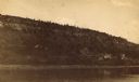
| Date: | 1887 |
|---|---|
| Description: | View over Mississippi River of town on shoreline with bluff in the background. |
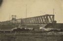
| Date: | 1866 |
|---|---|
| Description: | Clinton Bridge which crossed the Mississippi River at Clinton, Iowa. |
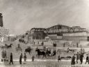
| Date: | 1891 |
|---|---|
| Description: | A painting of the new (as of 1891) bridge over the Mississippi River in La Crosse. The bridge was built by the Clinton Bridge Co. Captions read: "North sid... |

| Date: | 1804 |
|---|---|
| Description: | A map of Lewis and Clark's Track across the western portion of North America from the Mississippi River to the Pacific Ocean by order of the Executive of t... |

| Date: | 1829 |
|---|---|
| Description: | Cincinnati, Ohio, Ebr. Martin, engraver. |

| Date: | 1820 |
|---|---|
| Description: | A manuscript map of Prairie du Chien. |

| Date: | 1835 |
|---|---|
| Description: | Constructed for the Topographical Bureau [Wash.], 1835. Scale: 16 miles to 1 inch. Map of a portion of the Indian country lying east and west of the Missis... |

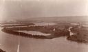
| Date: | 1870 |
|---|---|
| Description: | Half stereograph of an elevated view from hill showing the confluence of the Mississippi River and the St. Croix River. A man wearing a hat is in the foreg... |

| Date: | 1882 |
|---|---|
| Description: | This basic reference map of the state shows natural features, railroads, county seats, and political boundaries against the G.L.O. township and range grid.... |

| Date: | 1868 |
|---|---|
| Description: | Showing the counties, towns and railroads. Partly colored. Scale: 1 inch = 20 miles. |

| Date: | 1898 |
|---|---|
| Description: | Shows railway lines in Wisconsin marked in red and counties in colors. The meridians are Greenwich, Wisconsin and Washington, Wisconsin. The map folds into... |

| Date: | 1836 |
|---|---|
| Description: | Woodcut of Prairie du Chien in 1836. Text at bottom reads: "Prairie du Chien in 1836. From an old cut." |

| Date: | 1840 |
|---|---|
| Description: | Fort Crawford (the second site, with buildings of 1829-?), on the east bank of the Mississippi River, about 2 miles above the mouth of the Wisconsin River. |

| Date: | 1821 |
|---|---|
| Description: | A topographical view of the site of Fort Crawford. |
If you didn't find the material you searched for, our Library Reference Staff can help.
Call our reference desk at 608-264-6535 or email us at: