Filter: Subject of Maps

| Date: | |
|---|---|
| Description: | Looking West from Knight Block, with shipping piers and sailing ships on right side, railroad on left, trees in background. Horse-drawn carriages on street... |
| Date: | 1909 |
|---|---|
| Description: | Illustration of town. Caption reads: "Bird's-eye View, Lyons, Wisconsin. A Village of natural environments, choice residence locations, desirable factory s... |

| Date: | 1655 |
|---|---|
| Description: | Frontispiece to Newe Welt vnd americanische Historien (1655). |

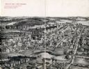
| Date: | 1905 |
|---|---|
| Description: | Bird's-eye view of Manitowoc on the shores of Lake Michigan. A map of the northeastern part of the United States at the top indicates Manitowoc's location ... |

| Date: | 1893 |
|---|---|
| Description: | Male and female students read and practice math at the State School for the Deaf as a teacher looks on from the head of the class. |
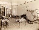
| Date: | 1893 |
|---|---|
| Description: | Interior of the State School for the Blind, perhaps a study or room for recreation. Included in the room are several tables with small models, a piano, and... |

| Date: | 1938 |
|---|---|
| Description: | A colorful pictorial map of Australia, featured on the front and back cover of a special Australian edition of International Trail. |
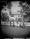
| Date: | 1874 |
|---|---|
| Description: | The Ole Wettlesen family poses in the yard in front of a picket fence with women knitting. Two standing men appear to be examining an unfolded map. The fra... |

| Date: | 08 24 1876 |
|---|---|
| Description: | Hand-drawn plan of the battleground of Huycks. |

| Date: | 03 26 1876 |
|---|---|
| Description: | Hand-drawn map showing the place of Hook's defeat in York County in South Carolina. |

| Date: | 1850 |
|---|---|
| Description: | Lithograph of a map drawn to indicate a mine on land owned by Mineral Point Mining Co. in the lead region of southwestern Wisconsin. |
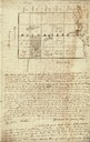
| Date: | 01 12 1844 |
|---|---|
| Description: | Letter from Thomas Steel, Waukesha County physician and farmer, to his father, James Steel, in London, England. It includes a hand-drawn map of Milwaukee C... |

| Date: | 05 05 1947 |
|---|---|
| Description: | Blaney Farms bookkeeper at a desk in the office. |
| Date: | |
|---|---|
| Description: | Plat map of Mammoth Cave. A note on the map reads: "Mrs. Campbell conjectures that this is a saltpeter cave in Green River, Kentucky. The mummy found in it... |
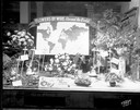
| Date: | 12 05 1952 |
|---|---|
| Description: | Rentschler Floral Company Floral Telegraph Delivery window display, "Flower's-by-Wire, Around the World." |
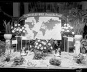
| Date: | 12 08 1952 |
|---|---|
| Description: | Rentschler Floral Company, 230 State Street, Floral Telegraph Delivery window display with plants and floral arrangements, banner with world map and "Flowe... |

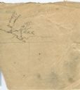
| Date: | |
|---|---|
| Description: | A very vague sketch of a map of North Racine, Wisconsin. |
| Date: | |
|---|---|
| Description: | A simple sketch of a section of Arkansas, showing the Arkansas River, White River and Helena, Arkansas. |

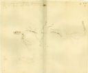
| Date: | 08 10 1862 |
|---|---|
| Description: | A hand-drawn map of the Battle of Wilson's Creek, Springfield, Missouri. Other notes and locations include: "Lyon was killed instantly while heading his tr... |
If you didn't find the material you searched for, our Library Reference Staff can help.
Call our reference desk at 608-264-6535 or email us at: