Filter: Subject of Maps

| Date: | 1925 |
|---|---|
| Description: | A map of the farm planned by Edwin Bottomley in 1844. |
| Date: | |
|---|---|
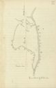
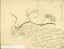
| Description: | Drawn map of the Catawba River, fishing creek, and surrounding landscape from the Sumter Papers. |
| Date: | |
|---|---|
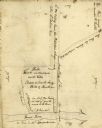
| Description: | Drawn map of Landsford, South Carolina, from Thomas Sumter Papers. |
| Date: | |
|---|---|
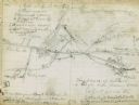
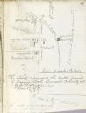
| Description: | Drawn map of the Hanging Rock Battlefield in the Thomas Sumter Papers. |
| Date: | |
|---|---|
| Description: | Drawn map of Hanging Rock Battlefield from the Thomas Sumter Papers. |
| Date: | |
|---|---|
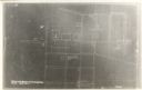
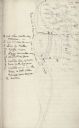
| Description: | Drawn map of Blackstock's Plantation battlefield from the Sumter Papers. |
| Date: | |
|---|---|
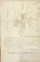
| Description: | Drawn map of the Fish Damn Ford battlefield from the Thomas Sumter Papers. |
| Date: | |
|---|---|
| Description: | Drawn map of Blackstock's Plantation battlefield from the Thomas Sumter Papers. |

| Date: | 08 01 1944 |
|---|---|
| Description: | Two workers at the United State Armed Forces Institute are: Robert Halverson and John Barr, recently in the armed services and participants in the educatio... |
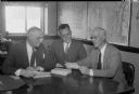
| Date: | 08 09 1944 |
|---|---|
| Description: | James R. Law, chairman of the Dane County Chapter of the National Foundation for Infantile Paralysis, Palmer F. Daugs, Lake Mills, representative of the Na... |
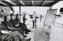
| Date: | 1971 |
|---|---|
| Description: | Secretary of Defense Melvin Laird, and several cigar-smoking officers are listening to a presentation about the war in Vietnam. |

| Date: | 09 15 1944 |
|---|---|
| Description: | Phyllis Wiswell, student at Central High School, compares a Wisconsin State Journal map with a classroom map to get a more complete picture of current even... |
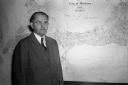
| Date: | 11 10 1944 |
|---|---|
| Description: | Mayor F. Halsey Kraege standing in front of a 1930 City of Madison map. |

| Date: | 1924 |
|---|---|
| Description: | Front and back covers of Scenic Wisconsin Motorways, a guide to Wisconsin roads compiled by Victor F. Pettric and published by the Wisconsin Motorists Asso... |

| Date: | 1904 |
|---|---|
| Description: | A map showing the design for a park fronting on Lake Monona Bay. (Now called Brittingham Park) taken from between pages 44 & 45 of the 1905 Madison Park a... |

| Date: | 12 26 1862 |
|---|---|
| Description: | Handsketched map of the area around Knobs Gap. |
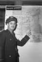
| Date: | 06 08 1945 |
|---|---|
| Description: | Marine Robert M. Crabb pointing to Japan on a map. He was home in Madison after serving as a war correspondent and being a prisoner of war for three years ... |

| Date: | |
|---|---|
| Description: | Map of location of bones, used in bison excavation project. |

| Date: | 1829 |
|---|---|
| Description: | Map of lead mines operating in Wisconsin. |
If you didn't find the material you searched for, our Library Reference Staff can help.
Call our reference desk at 608-264-6535 or email us at: