 Filter: Subject of Lead mines and mining

| Date: | 1920 |
|---|---|
| Description: | An ink on tracing paper, hand-drawn map that shows lead mines, the boundary of the lead bearing strata, and the military road in Lafayette, Grant, Iowa, an... |

| Date: | 1867 |
|---|---|
| Description: | This 1867 manuscript map by Increase Lapham shows the topography and geology of the Blue Mounds region in the Town of Brigham in Iowa County and the towns ... |

| From Sacred Calumets to Ashtrays |
|---|
| Discover the important role that tobacco and the Peace Pipe have played throughout Wisconsin's history. |
| A Short History of Wisconsin |
|---|
| Learn about the key people and events during Wisconsin's Territorial Era (1787-1848). |
| A Short History of Wisconsin |
|---|
| Read about immigration and economic growth in 19th-century Wisconsin. |
| The Birth of the Badgers |
|---|
| Discover the history of lead mining in Wisconsin, and the origin of Badgers. |
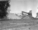
| Date: | |
|---|---|
| Description: | Exterior view of James Mine with a field and fence in the foreground. Tram tracks lead from the tall building to large piles of rocks. There are steep stai... |
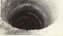
| Date: | |
|---|---|
| Description: | The 120 foot shot shaft below the shot tower at Tower Hill State Park. |

| Date: | 1888 |
|---|---|
| Description: | This is a reproduction of a map originally published in 1829 by R.W. Chandler, a pioneer settler of Galena. It is based on an earlier map by surveyor Luciu... |

| Date: | 1866 |
|---|---|
| Description: | This map shows the location of county boundaries, cities, rivers, lakes, grant railroads, wagon roads, land office locations, iron, copper and lead deposit... |

| Date: | 1805 |
|---|---|
| Description: | Map of the United States. It shows the states, cities, towns, Native American land, mountains, lakes, and rivers. Tennessee, Kentucky, and Ohio are labeled... |

| Date: | 1800 |
|---|---|
| Description: | Map of the United States. It shows the states, including Tennessee, cities, towns, Native American land, mountains, lakes, and rivers. Lead mines appear ju... |

| Date: | 1960 |
|---|---|
| Description: | A man is running his dog on a trail in an old lead mining area. The trees are bare and fallen leaves are covering the ground. |
If you didn't find the material you searched for, our Library Reference Staff can help.
Call our reference desk at 608-264-6535 or email us at: