Filter: Subject of Lead mines and mining
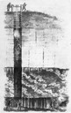
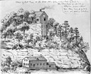
| Date: | 1844 |
|---|---|
| Description: | Cross section drawing of a Wisconsin lead mine. |
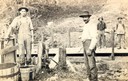
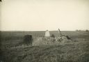
| Date: | |
|---|---|
| Description: | Miners probably grading galena (lead) ore by putting pieces in drums with holes and letting smaller ones fall through. |
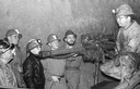
| Date: | 1950 |
|---|---|
| Description: | Students from Platteville, Wisconsin tour a mine to see how lead is extracted. |

| Date: | 1850 |
|---|---|
| Description: | Lithograph of a map drawn to indicate a mine on land owned by Mineral Point Mining Co. in the lead region of southwestern Wisconsin. |
| Date: | |
|---|---|
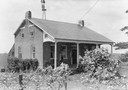
| Description: | Uppena home, built by Bernard Henry Uppena in 1850. |

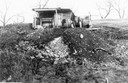
| Date: | 1948 |
|---|---|
| Description: | Large brick kiln-like structure in field. Built in 1876, the blast furnace was used to salvage additional lead from the slag of 18 area furnaces operating ... |
| Date: | 1900 |
|---|---|
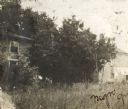
| Description: | View of the Gratiot homestead at Gratiot's Grove Site. |
| Date: | 1900 |
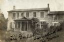
|---|---|
| Description: | Exterior view of the Gratiot homestead at Gratiot's Grove Site. Handwriting on front reads: "The Gratiot Homestead at the (?)on." |

| Date: | 1829 |
|---|---|
| Description: | Cincinnati, Ohio, Ebr. Martin, engraver. |

| Date: | 1829 |
|---|---|
| Description: | Map of lead mines operating in Wisconsin. |

| Date: | 1829 |
|---|---|
| Description: | Photoprint of Crawford County lead district map. |

| Date: | 1939 |
|---|---|
| Description: | International PA-100 power unit operating a Pomona water pump in a lead and zinc mine. A box labeled "dynamite" is in the foreground. |

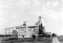
| Date: | 1936 |
|---|---|
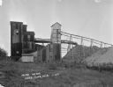
| Description: | View from road of lead and zinc mines and surrounding buildings. |
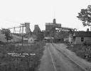
| Date: | 1925 |
|---|---|
| Description: | View down road leading up to the Cokerville Mine. Two horses pulling a wagon are near the road, and automobiles are parked on the right near a building wit... |
If you didn't find the material you searched for, our Library Reference Staff can help.
Call our reference desk at 608-264-6535 or email us at: