 Filter: Subject of Great Lakes
Filter: Year of 1800-1899
Filter: Subject of Great Lakes
Filter: Year of 1800-1899

| Date: | 1823 |
|---|---|
| Description: | In 1823 U.S. Army major Stephen H. Long led an expedition of scientific, trade, and military investigation up the Mississippi River and the Red River of th... |

| Date: | 1886 |
|---|---|
| Description: | Bird's-eye view of Ashland, on the shores of Lake Superior, with insets of The Apostle Islands Chequamagon Bay & Ashland, and Distances from Ashland. |

| Date: | 1850 |
|---|---|
| Description: | Pic Island on the north shore of Lake Superior. |
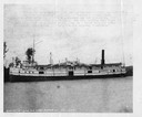
| Date: | 1880 |
|---|---|
| Description: | The screw passenger and freight vessel, Manistee. Faint typing on picture describes the loss of the Manistee on November 16, 1883. The ship <... |
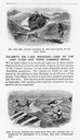
| Date: | 1859 |
|---|---|
| Description: | A page from Frank Leslie's Illustrated Newspaper with two sketches and a narrative of the sinking of the sidewheeler passenger, Lady Elgin, i... |
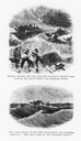
| Date: | 1859 |
|---|---|
| Description: | A page of Frank Leslie's Illustrated Newspaper detailing the sinking of the sidewheel passenger, Lady Elgin, in 1860. One sketch is of Edward... |

| Date: | 1886 |
|---|---|
| Description: | Bird's-eye view of Bayfield, county seat of Bayfield County. On the lower left side is an inset for Bayfield and the Apostle Islands. |

| Date: | 1862 |
|---|---|
| Description: | Drawn the second year of the Civil War, this 1862 map of Milwaukee shows post offices, light houses, beacon lights, county buildings, elevator warehouses, ... |

| Date: | 1883 |
|---|---|
| Description: | Bird's-eye map of Superior, county seat of Douglas County, on the shores of Lake Superior, with insets of points of interest. |

| Date: | 1886 |
|---|---|
| Description: | Bird's-eye map of Washburn on Lake Superior. There is an inset of Washburn, Chequamagon and the Apostle Islands. |

| Date: | 1898 |
|---|---|
| Description: | Bird's-eye map, looking west from shoreline on Lake Michigan of Milwaukee to Golden Lake in Waukesha County, with Kenosha and Fox Point at bottom corners, ... |

| Date: | 1879 |
|---|---|
| Description: | Bird's-eye map of Two Rivers. |

| Date: | 1896 |
|---|---|
| Description: | Bird's-eye view of Washburn, with twenty vignettes around side, water in foreground with docks and lumber corral. Thirty-three locations identified in key ... |

| Date: | 1836 |
|---|---|
| Description: | Map of the northern parts of Ohio, Indiana, and Illinois with Michigan and the part of "Ouisconsin" lying east of the Mississippi River. |

| Date: | 1831 |
|---|---|
| Description: | Map of the United States "constructed from the latest authorities," including a statistical table. |

| Date: | 1892 |
|---|---|
| Description: | Bird's-eye view of the Columbian Exposition pavilions from the vantage point of Lake Michigan. Included is an inset of the Union Passenger Station (now Uni... |

| Date: | 1844 |
|---|---|
| Description: | Map of Wisconsin including Lakes Michigan and Superior. Inset includes "N.W. Part of Wiskonsan." |

| Date: | 1857 |
|---|---|
| Description: | Information depicting the history, condition and prospects of the Indian tribes of the United States: collected and prepared under the direction of the Bur... |

| Date: | 1896 |
|---|---|
| Description: | Map showing the Wisconsin Central Railroad and its land grant, with the railroad and the land grant in color (red). |

| Date: | 1830 |
|---|---|
| Description: | A color map of the Michigan and Wisconsin territories with an inset showing the Ste. Marie River. |
If you didn't find the material you searched for, our Library Reference Staff can help.
Call our reference desk at 608-264-6535 or email us at: