Filter: Subject of Capitols
Filter: Subject of human settlements
Filter: Creator Name of Unknown
Filter: Subject of Capitols
Filter: Subject of human settlements
Filter: Creator Name of Unknown
| Date: | |
|---|---|
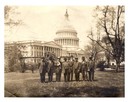
| Description: | Survivors of the Titanic sinking with Congressman William J. Cary and his Secretary, Richard P. Momsen, in front of the United States Capitol. |

| Date: | 1920 |
|---|---|
| Description: | A map of Madison and the vicinity. Red lines show the street railway. |
| Date: | |
|---|---|
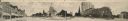
| Description: | Panoramic view of Capitol Square, seen from the West corner. Originally functioned as an oversized post card. Identifiable businesses include Haswell Furni... |
| Date: | |
|---|---|
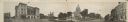
| Description: | Panoramic view of Capitol Square, seen from the South corner. Originally functioned as an oversized post card. Ringling Brothers Circus advertisement visib... |
| Date: | 1915 |
|---|---|
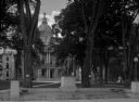
| Description: | A statue of Franklin Pierce in a park plaza surrounded by trees. The capitol building surmounted by the original war eagle statue fills the background. |
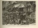
| Date: | 1814 |
|---|---|
| Description: | Etching depicting the burning of Washington, D.C. by the British during the War of 1812. In the foreground are a number of soldiers moving toward the Capit... |

| Date: | 1835 |
|---|---|
| Description: | Plat for a proposed Sinsinawa City (never built), in Grant County, Wis. When it became clear in the mid-1830s that Wisconsin Territory would be established... |

| Date: | 1961 |
|---|---|
| Description: | Shows wards and voting precincts. Published in The Capital times: January 28, 1961. |

| Date: | 1964 |
|---|---|
| Description: | Indexed map. Street names are to the left, map is to the right. Lakes, streets, highways, and points of interest are labelled. |

| Date: | 1873 |
|---|---|
| Description: | This map shows lots and blocks, additions and subdivisions, and large-scale landownership. The map is oriented with north to the upper right. The map is fr... |

| Date: | 1925 |
|---|---|
| Description: | This map shows the public schools and their school districts. The bottom of the map reads:" Old buildings and sites in red. New buildings and sites in blac... |

| Date: | 1930 |
|---|---|
| Description: | This map shows the western side of Madison, from Nakoma to the capitol. The map is oriented with north to upper right and the scale is indicated by quarter... |

| Date: | 1855 |
|---|---|
| Description: | This map shows a plat of the city, local streets, numbered blocks and lots, university grounds, the Capitol Square, and parts of Third and Fourth Lakes (La... |

| Date: | |
|---|---|
| Description: | Congressman David R. Obey and Senator William Proxmire outside the Capitol building in Washington, D.C. |

| Date: | 1980 |
|---|---|
| Description: | Steve Gunderson posing outdoors in front of the U.S. Capitol building. |
If you didn't find the material you searched for, our Library Reference Staff can help.
Call our reference desk at 608-264-6535 or email us at: