 Filter: Subject of Boats and boating
Filter: Subject of coasts
Filter: Subject of Boats and boating
Filter: Subject of coasts
| Date: | |
|---|---|
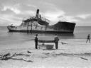
| Description: | View from shoreline toward the wreck of the S.S. Atlantus, a concrete hulled ship in the water near a shoreline. In the foreground are three men on ... |
| Date: | |
|---|---|
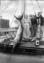
| Description: | Fishermen and women pose with a swordfish tied to a mast aboard a boat. |

| Date: | |
|---|---|
| Description: | View along shoreline toward a lighthouse and homes standing on Rocky Point. There are several boats anchored at the shore and in the water. |

| Date: | |
|---|---|
| Description: | Aerial view of harbors and bridge. Farm fields are on either side of the bridge. The city of Sturgeon Bay is in the distance. There are docks along the sho... |

| Date: | 1902 |
|---|---|
| Description: | This map is a chart of Milwaukee Harbor that displays local streets, bridges, roads, railroads, public buildings, businesses, factories, dry docks, parks, ... |

| Date: | 1755 |
|---|---|
| Description: | Map of the northeastern portion of America and Canada, east of the Hudson River and south from Labrador. It names regions, colonies, cities, numerous forts... |
If you didn't find the material you searched for, our Library Reference Staff can help.
Call our reference desk at 608-264-6535 or email us at: