 Filter: FULL_DATE of 1960
Filter: Subject of express highways
Filter: FULL_DATE of 1960
Filter: Subject of express highways
| Date: | 1960 |
|---|---|
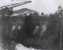
| Description: | Excavation for bridge column footings for the Mirror Lake Bridge. |
| Date: | 1960 |
|---|---|
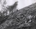
| Description: | View from below looking up towards workers constructing and reinforcing the forms for the footings of the interstate highway bridge at Mirror Lake. |
| Date: | 1960 |
|---|---|
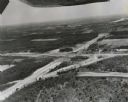
| Description: | Aerial view of the intersection of the interstate highway with USH 12 between Baraboo and Lake Delton with the initial grading largely completed. |

| Date: | 1960 |
|---|---|
| Description: | Aerial view of the construction of the interstate highway near Mirror Lake, showing only the early stages of the bridge construction. |

| Date: | 1960 |
|---|---|
| Description: | Color coded map in pink, yellow, blue, and brown of Milwaukee County State and County trunk highways. The map includes a legend of symbols: "STEAM RAIL ROA... |
| Date: | 1960 |
|---|---|
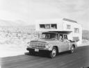
| Description: | Man, woman, and a young child holding a pinwheel outside the window, are riding in an International 1966 Travelette pickup with camper attached. They are t... |

| Date: | 1960 |
|---|---|
| Description: | This map shows public boat ramps, parks, highways, beaches, bluffs, Green Bay, Garrett Bay, Europe Bay and Lake, Rowley's Bay and Ellison Bay. The map incl... |

| Date: | 1960 |
|---|---|
| Description: | This map shows uplands and swamps owned by the Goodman Lumber Division, water, and roads. The lower right corner includes a location map. The upper left co... |

| Date: | 1960 |
|---|---|
| Description: | This colored road map shows roads in Wisconsin as well as portions of nearby states. Information on the quality and type of any road shown can be found in ... |
If you didn't find the material you searched for, our Library Reference Staff can help.
Call our reference desk at 608-264-6535 or email us at:
