 Filter: FULL_DATE of 1878
Filter: County of Crawford
Filter: FULL_DATE of 1878
Filter: County of Crawford

| Date: | 1878 |
|---|---|
| Description: | Illustrated map of Crawford County. On the bottom right is an inset of a group of people near a train on a railroad track. |

| Date: | 1878 |
|---|---|
| Description: | This map of Crawford County, Wisconsin, shows the township and range grid, sections, towns, cities and villages, land ownership and acreages, roads, railro... |
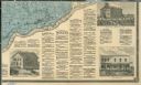
| Date: | 1878 |
|---|---|
| Description: | The bottom right corner of a map of Crawford County. This portion of the map includes town directories and illustrations of the Court House in Prairie Du C... |
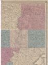
| Date: | 1878 |
|---|---|
| Description: | Portion of a map of Crawford County. |
If you didn't find the material you searched for, our Library Reference Staff can help.
Call our reference desk at 608-264-6535 or email us at: