Filter: FORMAT_TYPE of drawings
Filter: County of Brown
Filter: FORMAT_TYPE of drawings
Filter: County of Brown
| Date: | |
|---|---|
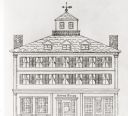
| Description: | Pencil drawing of the building with a decorative frieze in a pediment above the columned entrance. |
| Date: | |
|---|---|
| Description: | View of a fort with fortified walls and a flag flying from the fort. A river runs on the right of the image. A boat with sails floats on the river. Sold... |

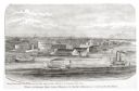
| Date: | 1851 |
|---|---|
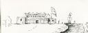
| Description: | Several men rowing in a boat near Fort Howard that has an American Flag, barracks, and various related military buildings enclosed behind a wall. |
| Date: | 1857 |
|---|---|
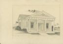
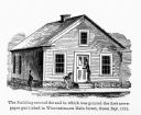
| Description: | Green Bay Intelligencer Newspaper Office. This was the first newspaper published in Wisconsin. The building was on Main Street. This drawing appeared in an... |
| Date: | 1957 |
|---|---|
| Description: | Plot plan for a proposed transportation museum. |
| Date: | 1876 |
|---|---|
| Description: | View looking southeast over river from Elmore and Kelly's Elevator. |
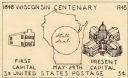
| Date: | |
|---|---|
| Description: | Line drawing in black ink of a design for the Wisconsin Centennial 3 cent postage stamp, featuring Wisconsin State Capitol buildings. The artist used the w... |
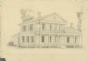
| Date: | 1946 |
|---|---|
| Description: | Pencil drawing of a house at 421 Cass Street. The main entrance is on a long porch with columns, under a balcony. There is a side entrance on the left. |

| Date: | 1835 |
|---|---|
| Description: | Ink on tracing paper map of Green Bay, Wisconsin and nearby areas, Lake Winnebago, Fox and Wolf Rivers, and the junctions of the Mississippi and Wisconsin ... |

| Date: | 1890 |
|---|---|
| Description: | These hand-colored maps show the sections, lakes, swamps, streams, and state, vacant, entered, and withdrawn lands in ten survey townships in Oneida, Vilas... |

| Date: | |
|---|---|
| Description: | This 19th century manuscript map shows lots and acreages in northern Green Bay, Wisconsin, east of the Fox River. "Preble Township, Brown County, Wis." is ... |

| Date: | 1836 |
|---|---|
| Description: | This manuscript shows the 1835 survey of the road corresponding approximately to a portion of County Trunk A in the Town of Scott, Brown County, Wisconsin.... |

| Date: | 1830 |
|---|---|
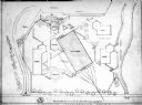
| Description: | Plat map showing lots and streets. A few lots are marked with names, including: Boyd, Newton, Williams, Baird, Suydam, etc. |

| Date: | 1829 |
|---|---|
| Description: | This map of Munnomonee is ink and pencil on tracing cloth. The map shows a plat of the town, local streets, highways, land donations for public use, and pa... |

| Date: | 09 20 1836 |
|---|---|
| Description: | This map is ink and watercolor on paper and is an unnamed plat. Green Bay is labeled and the plat is labeled "Section 22." One road is labeled "Road to Nav... |

| Date: | 1844 |
|---|---|
| Description: | This map of Township number 24 North, Range 21 East is pen and ink on paper. The map also shows part of Township Number 23 North, Range Number 21 East. The... |

| Date: | 1800 |
|---|---|
| Description: | This map of the Little Kaukalin Region is ink on paper and shows Little Kaukalin Rapids, Black Bird Island, buildings, trails, meadows and woods, and a sug... |
If you didn't find the material you searched for, our Library Reference Staff can help.
Call our reference desk at 608-264-6535 or email us at: