 Filter: County of Outagamie
Filter: Subject of architecture
Filter: County of Outagamie
Filter: Subject of architecture

| Date: | |
|---|---|
| Description: | Billhead of Star Brewery of Appleton, Wisconsin, with an elevated three-quarter view of the brewery and surrounding streets and buildings. On the right sid... |
| Date: | |
|---|---|
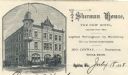
| Description: | Letterhead of Sherman House of Appleton, Wisconsin, with a three-quarter view of the hotel and people standing on the corner, walking on the sidewalk, or d... |
| Date: | |
|---|---|
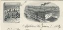
| Description: | Letterhead of the Atlas Paper Company of Appleton, Wisconsin, a paper company established in 1878. On the left is a scroll embellished with a spray of flow... |
| Date: | |
|---|---|
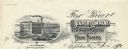
| Description: | Letterhead of the Fox River Paper Company of Appleton, Wisconsin, with a three-quarter view of the company building and a hanging roll of paper that incorp... |
| Date: | 1960 |
|---|---|
| Description: | A Wisconsin State Canners Truck parked under a chute at Stokely Van Camp canning factory on West College Avenue. |

| Date: | 1903 |
|---|---|
| Description: | This 1903 map of Outagamie County, Wisconsin, shows the township and range grid, towns, sections, cities and villages, landownership and acreages, rural ma... |

| Date: | |
|---|---|
| Description: | This 1907 map of Outagamie County, Wisconsin, shows the township and range grid, towns, sections, cities and villages, railroads, wagon roads, churches, sc... |

| Date: | 1922 |
|---|---|
| Description: | This map of Outagamie County, Wisconsin, from the first half of the 20th century, shows the township and range grid, towns, sections, cities and villages, ... |
| Date: | |
|---|---|
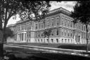
| Description: | Exterior view of Appleton High School. Caption reads: "High School - Appleton, Wis." |
| Date: | |
|---|---|
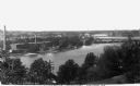
| Description: | Elevated view of hydroelectric plants on the Fox River. Caption reads: "Water Power - Looking West. Appleton, Wis." |
| Date: | |
|---|---|
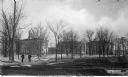
| Description: | View of Lawrence University campus. Two men stand on the sidewalk in the foreground. Caption reads: "Lawrence University Campus, Appleton, Wis." |
| Date: | |
|---|---|
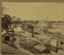
| Description: | Elevated view of a lock at Appleton, with views of mills and other structures in the background. |

| Photographs of Public Libraries in Wisconsin |
|---|
| Learn about how the Wisconsin Free Library Commission helped to establish and improve free public libraries in Wisconsin. |

| Date: | 1873 |
|---|---|
| Description: | Map shows townships and sections, landownership and acreages, state and county lands, churches, schools, cemeteries, roads, and railroads. There is an inse... |

| Date: | 1874 |
|---|---|
| Description: | Bird's-eye view map of Appleton, Wisconsin. Map reads: "NOTE.-Since the above cut was engraved, the Fox River Pulp & Paper Co.'s Mammoth Mills have been er... |

| Date: | 04 1956 |
|---|---|
| Description: | Map includes an index for building locations on the Lawrence University campus in the upper right hand corner. Map shows roads, rivers, campus buildings by... |
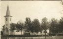
| Date: | 1913 |
|---|---|
| Description: | Photographic postcard view of a town block with a church and two houses along a tree-lined street. Two young children are standing on the sidewalk. Caption... |
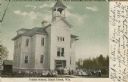
| Date: | 1909 |
|---|---|
| Description: | Exterior view of a school. Students and teachers are gathered in front. Caption reads: "Public School, Black Creek, Wis." |

| Date: | 1889 |
|---|---|
| Description: | Mrs. Cadle seated in a bedroom, looking out a window. On the table in front of her is a cup and saucer. |

| Date: | 1890 |
|---|---|
| Description: | This map is a plat map and shows government buildings, churches, Klein’s Park, and the government dam in Kaukauna. The map includes text about Kaukauna wit... |
If you didn't find the material you searched for, our Library Reference Staff can help.
Call our reference desk at 608-264-6535 or email us at: