Filter: County of Langlade

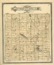
| Date: | 1908 |
|---|---|
| Description: | Map shows townships and sections, landownership and acreages, rural routes, roads, railroads, creameries, churches, schools, and town halls. Sections appea... |
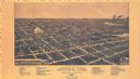
| Date: | 1886 |
|---|---|
| Description: | Bird’s-eye-view map. Map includes illustrations and index to points of interest. |

| Date: | 1926 |
|---|---|
| Description: | Map shows land ownership and streets in the town of Antigo. |

| Date: | 1909 |
|---|---|
| Description: | Street view showing houses, side yards and residents. |
| Date: | 1885 |
|---|---|
| Description: | View of Clermont Street with a young boy in the foreground, homes and trees in the background. Fences and sidewalks line both sides of the street. |

| Date: | 1921 |
|---|---|
| Description: | Elevated view of automobiles and trucks gathered in connection with the distribution of brook trout fish. The “milk” cans in sight presumably contain finge... |

| Date: | 1913 |
|---|---|
| Description: | View of side and front of the St. Ambrose Episcopal Church. Two people are standing near the ivy which is growing up the side of the tower near the arched ... |

| Date: | 1950 |
|---|---|
| Description: | Aerial view of town, showing all of Lake Metonga in the background. Caption reads: "Greetings from Crandon, Wisconsin." |

| Date: | 1911 |
|---|---|
| Description: | View of an overturned delivery wagon near M. Krachmer's camp, five miles north of Antigo. Caption reads: "A Bad Spill By M. Krachner's." |

| Date: | 1947 |
|---|---|
| Description: | This map shows lakes, rivers, railroads, and the soil types of Langlade County. Legends of soil types, conventional signs, and stoniness and slope are incl... |
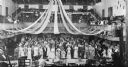
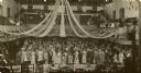
| Date: | 04 15 1910 |
|---|---|
| Description: | Elevated interior view of prom attendants assembled in a gym. Streamers are hanging from the ceiling. Some people are watching from the balcony. |

| Date: | 1960 |
|---|---|
| Description: | This pictorial map shows recreation activities, rivers, lakes, and the history of the area. The map covers Langlade County and parts of adjacent counties. ... |

| Date: | 1966 |
|---|---|
| Description: | This map shows trails, roads, creeks, alleged location of George Gardner's trading post, Boulder and Mud Lakes, and a portion of the Wolf River. The map al... |
| Date: | 1913 |
|---|---|
| Description: | A plat map of the township of Norwood in Langlade County. |
| Date: | 1924 |
|---|---|
| Description: | Photographic postcard view of a wood-frame home with young trees in the large yard. A lamppost is on the corner. Other homes are further down the block. Ca... |

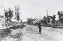
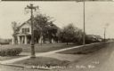
| Date: | 1907 |
|---|---|
| Description: | View looking down center of unpaved main street. The street is lined with dwellings with fenced-in yards. Caption reads: "Elton, Wis." |
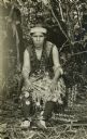
| Date: | 1908 |
|---|---|
| Description: | Photographic postcard of Qua-bas-er-o-qua, an Ojibwa (Chippewa) woman. She is seated on the ground in a low woven chair, and is wearing traditional clothin... |
| Date: | 04 15 1910 |
|---|---|
| Description: | Elevated view from stage towards a large group of young people in formal attire standing in a decorated gymnasium. People are also up in the balcony. Capti... |
If you didn't find the material you searched for, our Library Reference Staff can help.
Call our reference desk at 608-264-6535 or email us at: