 Filter: County of Iron
Filter: Year of 1800-1899
Filter: County of Iron
Filter: Year of 1800-1899

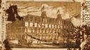
| Date: | 1886 |
|---|---|
| Description: | Bird's-eye map of Hurley with insets Mining at the Colby, Hurley in 1885, and North Front of Silver Street. |
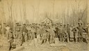
| Date: | 1886 |
|---|---|
| Description: | Outdoor group portrait of the Gogebic Range iron miners. |
| Date: | 1885 |
|---|---|
| Description: | Burton House, (also referred to as the Ridge House by Edna Ferber in her novel, "Come and Get It") with horse-drawn carriages in the foreground. |

| Date: | 1887 |
|---|---|
| Description: | Benedict & Co. engineers. As shown by development to March 1st 1887. Inset: Map of northern Wisconsin showing location of range. Lands in red. |
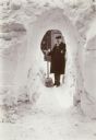
| Date: | 03 1899 |
|---|---|
| Description: | Winter scene of man wearing an overcoat and hat stands with a shovel at the far end of a snow tunnel shoveled through a tall snowbank. |

| Date: | 09 27 1895 |
|---|---|
| Description: | Elevated view of men and horses standing atop the platform used to load wood into charcoal kilns, also known as pits. These kilns convert cord wood into ch... |
| Date: | 09 27 1895 |
|---|---|
| Description: | A plot of land in front of a row of houses features cabbage in the foreground, ripe, four-foot tall Havana seed leaf tobacco plants in the center, and swee... |

| Date: | 1896 |
|---|---|
| Description: | A map of Iron County, Wisconsin, shows vacant Wisconsin Central Rail Road lands, settlers houses, land sold by Wisconsin Central R.R., schools, churches, s... |

| Date: | 1898 |
|---|---|
| Description: | A map of Iron County, Wisconsin, shows vacant Wisconsin Central Rail Road lands, settlers houses, land sold by Wisconsin Central R.R., schools, churches, s... |

| Spiritualist and Psychic Healer |
|---|
| Biography of spiritualist and psychic healer Mary Hayes Chynoweth. |
| The Boom and Bust of the 19th Century |
|---|
| Discover how the copper boom and bust of the 19th century permanently altered the communities of northern Wisconsin. |

| Date: | 09 1891 |
|---|---|
| Description: | Sanborn map of Hurley, featuring the Village of Gile and the Montreal River Lumber Company. |

| Date: | 1898 |
|---|---|
| Description: | Sanborn map of Hurley featuring the Village of Gile. |

| Date: | 02 1898 |
|---|---|
| Description: | Sanborn map of Hurley featuring the Montreal Mining Company. |

| Date: | 1892 |
|---|---|
| Description: | This map shows rivers, lakes, railroad lines, roads, and communities in addition to geological data. The map includes cross-sections in the bottom margin a... |

| Date: | 1887 |
|---|---|
| Description: | A view of the businesses present on Silver Street, Hurley's main street, less than three years after the city's settlement. City residents and a horse-dra... |

| Location: | The location of the wreck has not been found. On November 20, 1883 the tug <i>Maytham</i> happened onto a field of wreckage including parts of the <i>Manistee's</i> superstructure approximately forty-five miles northeast of Ontonagon, Michigan. Later, the freighter <i>Osceola</i> found wreckage and portions of the <i>Manistee's</i> cargo off of the Apostle Islands. The tug <i>Swain</i> found more wreckage off of Eagle River. The rudder and barreled flour came ashore near Copper Harbor. The west shore of Keweenaw Point was littered with miscellaneous items such as beds, tables, buckets, and food many of which had <i>Manistee's</i> name on it. |
|---|---|
| Ship Master: | Captain John Mckay. |
| Body of water: | Lake Superior |
If you didn't find the material you searched for, our Library Reference Staff can help.
Call our reference desk at 608-264-6535 or email us at:
