 Filter: County of Dunn
Filter: Year of 1800-1899
Filter: Subject of transportation
Filter: County of Dunn
Filter: Year of 1800-1899
Filter: Subject of transportation
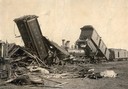
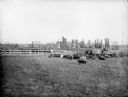
| Date: | 09 09 1881 |
|---|---|
| Description: | Wreck of the Chicago, St. Paul, Minneapolis and Omaha railroad line on the Teegarten farm near Menomonie. Dead cows are in the foreground. |

| Date: | 1897 |
|---|---|
| Description: | Exterior view of a farmhouse with a picket fence. In front of the house are two men and a horse-drawn carriage. |

| Date: | 1897 |
|---|---|
| Description: | View down dirt road, with a few homes on each side of the lane. |
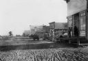
| Date: | 1897 |
|---|---|
| Description: | A dirt street in the business district of Wheeler. |
| Date: | 1897 |
|---|---|
| Description: | Road lined with fences leading into town. Several houses are visible in the distance. A railroad track and electric or telegraph line runs along the left s... |
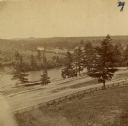
| Date: | 1880 |
|---|---|
| Description: | The view of Red Cedar River from Meadow Hill. |
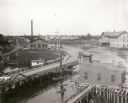
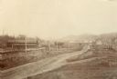
| Date: | 1899 |
|---|---|
| Description: | Elevated view looking north towards Menomonie, the Knapp, Stout and Company lumber mills. |
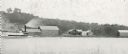
| Date: | 1895 |
|---|---|
| Description: | Rumsey's Landing on the Chippewa River about two miles below Caryville. |

| Date: | 1887 |
|---|---|
| Description: | Mill workers in the yard at Ramsay & Jones Mill. |

| Date: | 1887 |
|---|---|
| Description: | The bay shore of Menominee filled with driftwood. |
| Date: | 10 12 1895 |
|---|---|
| Description: | Forty-nine hogs at feeding time on the farm of William Miller. The hogs are eleven-months old and weigh approximately 260 lbs each. A wagon and horse team ... |

| Date: | 1855 |
|---|---|
| Description: | Map reads: "Knapp, Stout & Co., William Carson, Henry Eaton, Amos Collum, William Wilson & C.S. Bundy Proprietors."Streets running horizontally begin at th... |

| Date: | 1890 |
|---|---|
| Description: | Shows plat of town, local streets, steam boat landings, and Chippewa River. Public square and Muskoo Island hand-colored. Map reads: "Full Lots are 125x66 ... |
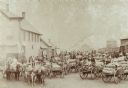
| Date: | 1898 |
|---|---|
| Description: | Farmers with their loads waiting to ship on train number 40 at Colfax, Wisconsin. "An everyday occurrence at 3:50 pm during September and October." |

| Date: | 1859 |
|---|---|
| Description: | This plat map is pen on paper and shows numbered blocks and lots, local streets, and section lines. Also included is text on survey certifications. |

| Date: | 1859 |
|---|---|
| Description: | This plat map is pen on paper and shows numbered blocks and lots, local streets, and section lines. Also included is text on survey certifications. The top... |

| Date: | 1875 |
|---|---|
| Description: | This plat map shows local streets, buildings, numbered blocks and lots, part of the Red Cedar River, and land ownership by name. Also included is a busines... |

| Date: | 1896 |
|---|---|
| Description: | This map shows plat of town, local streets, numbered blocks and lots, mill pond, mills, part of the Red Cedar River, and land and property ownership by nam... |

| Date: | 1877 |
|---|---|
| Description: | This map is a photstat copy of the original and shows landownership, townships and sections, wagon roads, railroads, school houses, churches, cemeteries, m... |
If you didn't find the material you searched for, our Library Reference Staff can help.
Call our reference desk at 608-264-6535 or email us at: