 Filter: Community of Trempealeau
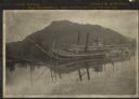
| Date: | 1906 |
|---|---|
| Description: | View across water towards the steamer Quincy, of the Diamond Jo Line, partially sunken into the Mississippi River and listing to port near the shore... |

| Date: | 1920 |
|---|---|
| Description: | This blue print map shows landownership between 1913 and 1916, topography, railroads, and roads. The map covers the vicinity of Perrot State Park. |
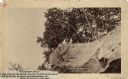
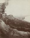
| Date: | 1888 |
|---|---|
| Description: | View looking up at three men and a child on top of a cliff on which are petroglyphs. Caption on photograph reads: "Pictograph Rock. Rock bearing aboriginal... |
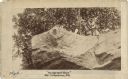
| Date: | 1888 |
|---|---|
| Description: | View looking up at three men and a child on top of a cliff on which are petroglyphs. Pictograph Rock bearing aboriginal carvings, located on the south side... |
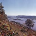
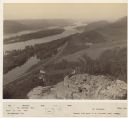
| Date: | 1972 |
|---|---|
| Description: | Elevated view looking south towards the Mississippi River from Brady's Bluff in Perrot State Park. |

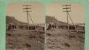
| Date: | 01 28 1862 |
|---|---|
| Description: | Letterhead depicting a scene in the Battle of Big Bethel, in which Lieutenant John T. Greble refused to pull back, as he continued to fire his last cannon.... |

| Date: | 04 18 1888 |
|---|---|
| Description: | A stereograph of ruins of a fireplace in an old French fort on the banks of the Mississippi River. The fort may have been built by Nicholas Perrot. |
| Date: | 04 18 1888 |
|---|---|
| Description: | Stereograph of fireplace ruins on the site of an old French fort, possibly built by Nicholas Perrot. There is an electric pole behind the fireplace and a g... |
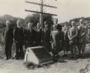
| Date: | 09 06 1926 |
|---|---|
| Description: | Group portrait of attendees at a ceremony to place a marker on the former site of the French post of Nicolas Perrot. From left to right are Dr. Eben D. Pie... |
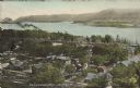
| Date: | |
|---|---|
| Description: | View of Trempealeau from bluffs north of the town, looking south towards the Mississippi river. |
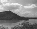
| Date: | 1952 |
|---|---|
| Description: | View of Perrot State Park from the opposite shore of the Mississippi river. |
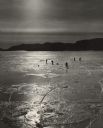
| Date: | 1961 |
|---|---|
| Description: | People ice fishing on the frozen Mississippi River. Hills can be seen on the shoreline in the background. |
| Date: | 1936 |
|---|---|
| Description: | Text on front reads: "Trempealeau Wis. on the Great River Road overlooking Lock & Dam No. 6 on the Upper Mississippi." On reverse: "Lock & Dam No. 6, one o... |

| Date: | 1950 |
|---|---|
| Description: | Text on front reads: "Main Street - Trempealeau, Wisconsin." On reverse: "On the Grand Old Mississippi and the Great River Road near Perrot State Park and ... |
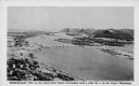
| Date: | 1920 |
|---|---|
| Description: | Text on front reads: "Trempealeau, Wis., on-the-Mississippi." Aerial view of the town on the Mississippi River. |

| Date: | 09 04 1913 |
|---|---|
| Description: | Text on front reads: "'Castle Rock,' 2nd Peak, Trempealeau, Wis., on-the-Mississippi." Elevated view towards a rock formation on the Mississippi River. Isl... |
| Date: | 1880 |
|---|---|
| Description: | Elevated view of two men on a rock formation in the foreground, one man sitting, and one man standing holding a flag. Below them is the Mississippi River a... |

| Date: | 1885 |
|---|---|
| Description: | Elevated view over trees towards the Mississippi River. 1885-90. Across the field in the foreground are people with an American flag standing along the sho... |

| Community: | Trempealeau |
|---|---|
| County: | Trempealeau |
| Historic Name: | Citizens State Bank |
| Reference Number: | 16860 |
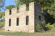
| Community: | Trempealeau |
|---|---|
| County: | Trempealeau |
| Historic Name: | MELCHOIR BREWERY AND HOTEL |
| Reference Number: | 16861 |
If you didn't find the material you searched for, our Library Reference Staff can help.
Call our reference desk at 608-264-6535 or email us at: