 Filter: Community of Porterfield

| Date: | 1851 |
|---|---|
| Description: | This manuscript map of the southern portion of the Town of Porterfield, Marinette County, Wisconsin, shows sections and land ownership. The Menominee River... |

| Date: | 1887 |
|---|---|
| Description: | This manuscript map of the southern portion of the Town of Porterfield, Marinette County, Wisconsin, shows sections and land ownership. The Menominee River... |
| Community: | Porterfield |
|---|---|
| County: | Marinette |
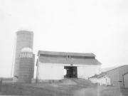
| Historic Name: | RICK HANSEN FARM |
| Reference Number: | 18209 |
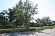
| Community: | Porterfield |
|---|---|
| County: | Marinette |
| Historic Name: | |
| Reference Number: | 207001 |
If you didn't find the material you searched for, our Library Reference Staff can help.
Call our reference desk at 608-264-6535 or email us at: