 Filter: Community of Meridean
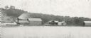
| Date: | 1895 |
|---|---|
| Description: | Rumsey's Landing on the Chippewa River about two miles below Caryville. |
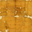
| Date: | 1860 |
|---|---|
| Description: | Pencil and ink on paper. "Showing the government meander line on the left bank of Rock River and the actual course of Rock River together with the several ... |
If you didn't find the material you searched for, our Library Reference Staff can help.
Call our reference desk at 608-264-6535 or email us at: