 Filter: Community of Menomonie
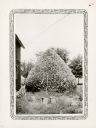
| Date: | 1932 |
|---|---|
| Description: | A conical stack of stovewood owned by Delbert Karns of 9th Street, Menomonie stands beside a house. It contained 55 cords of wood. |
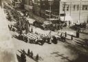
| Date: | 11 11 1918 |
|---|---|
| Description: | Elevated view from building of informal Armistice Day street parade at an intersection of the downtown area. They are celebrating the conclusion of the fir... |
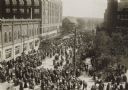
| Date: | 11 11 1918 |
|---|---|
| Description: | Elevated view from building of informal Armistice Day street parade at an intersection of the downtown area. They are celebrating the conclusion of the fir... |
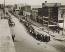
| Date: | 05 21 1919 |
|---|---|
| Description: | Elevated view of street entertainment, with crowds, dancing and band concert to welcome home Wisconsin National Guard, 3d Regiment, Company H, after servic... |

| Date: | 1960 |
|---|---|
| Description: | This map shows lot and block numbers, additions, and rural acreages and includes an index of rail roads, industrial plants, Dunn County and Menominee owned... |

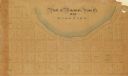
| Date: | 1859 |
|---|---|
| Description: | This plat map is pen on paper and shows numbered blocks and lots, local streets, and section lines. Also included is text on survey certifications. |

| Date: | 1859 |
|---|---|
| Description: | This plat map is pen on paper and shows numbered blocks and lots, local streets, and section lines. Also included is text on survey certifications. The top... |
| Date: | |
|---|---|
| Description: | This plat map is pen, pencil, and watercolor on paper and shows numbered blocks and lots, local streets, section lines, the public square, Mill pond, and l... |

| Date: | 1875 |
|---|---|
| Description: | This plat map shows local streets, buildings, numbered blocks and lots, part of the Red Cedar River, and land ownership by name. Also included is a busines... |

| Date: | 1896 |
|---|---|
| Description: | This map shows plat of town, local streets, numbered blocks and lots, mill pond, mills, part of the Red Cedar River, and land and property ownership by nam... |

| Date: | 1911 |
|---|---|
| Description: | This map shows plat of town, local streets, numbered lots, blocks, and wards, roads, Lake Menomin, Wilson Creek, Red Cedar River, and land ownership by nam... |

| Date: | 1907 |
|---|---|
| Description: | This blueprint map shows a proposed plan for pleasure roads and reservation system. It also shows schools, cemeteries, old river channel, proposed bridge, ... |

| Date: | 07 04 1899 |
|---|---|
| Description: | Fourth of July Barbecue in Menomonie arranged by the citizens and inspected by J.H. Stout. Thirteen quarters of beef were roasted and 8000 pints of soup se... |

| Date: | 1931 |
|---|---|
| Description: | This photocopy map shows lot and block numbers, some landownership and acreages, water flowage, and marshes. The map also shows Lake Menomin and Wilson Cr... |

| Date: | 03 09 1936 |
|---|---|
| Description: | Two men in work clothes are bending over a box they are constructing from slab wood near Lake Menomin. There is snow on the ground and a park shelter in th... |
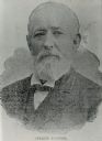
| Date: | |
|---|---|
| Description: | Reproduction of a portrait of Andrew Tainter, a lumber baron from Menomonie. Mr. Tainter and his family were influential in the building of Menomonie. |
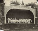
| Date: | 1933 |
|---|---|
| Description: | View across lawn towards band members posing in their uniforms and holding their musical instruments. The group is sitting and standing on stage under a ba... |

| Date: | 1909 |
|---|---|
| Description: | Birds-eye view of Menominie, dwellings and churches. Caption reads: "Bird's-Eye View, Menomonie, Wis." |

| Date: | |
|---|---|
| Description: | View across lake toward a large multi-level boat house on the shoreline. Caption reads: "The Boat House on Lake Menomin. Menomonie, Wis." |

| Date: | 1908 |
|---|---|
| Description: | Dam on the Red Cedar River. Caption reads: "Red Cedar Dam, Menomonie, Wis." |
If you didn't find the material you searched for, our Library Reference Staff can help.
Call our reference desk at 608-264-6535 or email us at: