Filter: Community of Cedarburg

| Community: | Cedarburg |
|---|---|
| County: | Ozaukee |
| Historic Name: | Hilgen and Wittenberg Woolen Mill |
| Reference Number: | 78000124 |
| Community: | Cedarburg |
|---|---|
| County: | Ozaukee |
| Historic Name: | Wayside House |
| Reference Number: | 82000694 |
| Community: | Cedarburg |
|---|---|
| County: | Ozaukee |
| Historic Name: | Columbia Historic District |
| Reference Number: | 91001980 |
| Community: | Cedarburg |
|---|---|
| County: | Ozaukee |
| Historic Name: | Hilgen, Friedrich and Louisa, House |
| Reference Number: | 92001027 |
| Community: | Cedarburg |
|---|---|
| County: | Ozaukee |
| Historic Name: | Cedarburg Mill |
| Reference Number: | 74000115 |
| Community: | Cedarburg |
|---|---|
| County: | Ozaukee |
| Historic Name: | Concordia Mill |
| Reference Number: | 74000116 |
| Community: | Cedarburg |
|---|---|
| County: | Ozaukee |
| Historic Name: | Covered Bridge |
| Reference Number: | 73000092 |
| Community: | Cedarburg |
|---|---|
| County: | Ozaukee |
| Historic Name: | Hamilton Historic District |
| Reference Number: | 76000070 |
| Community: | Cedarburg |
|---|---|
| County: | Ozaukee |
| Historic Name: | Washington Avenue Historic District |
| Reference Number: | 86000218 |
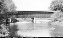
| Date: | 1940 |
|---|---|
| Description: | Exterior view of the last covered bridge in Wisconsin. Caption reads: "Covered Bridge Near Cedarburg, Wis." |

| Date: | 06 17 1987 |
|---|---|
| Description: | Kids smiling gleefully on the Tilt-a-Whirl carnival ride while workers manage the controls in the background on a sunny summer day. |

| Date: | 1882 |
|---|---|
| Description: | This map of Cedarburg is a bird's-eye map with an inset of Cedarburg Brewery. Relief is shown pictorially and the map includes an index to buildings. |

| Date: | 2007 |
|---|---|
| Description: | This map of Cedarbug is a bird's-eye map with 8 inset views and an index. The map is a print out of the original map dated 1892 held at the Cedarburg Cultu... |
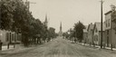
| Date: | 1907 |
|---|---|
| Description: | View down center of unpaved street in Cedarburg, with a large church at the far end. |
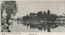
| Date: | 1905 |
|---|---|
| Description: | View of Cedarburg across water. Caption reads: "Cedarburg, Wis." |
| Date: | 1907 |
|---|---|
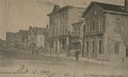
| Description: | View across Washington Avenue. A man is standing in the street near the curb. Caption reads: "Cedarburg, Wis., Washington Avenue looking North." |
| Date: | 1905 |
|---|---|
| Description: | North view down Washington Avenue. Caption reads: "'Washington Ave., North' Cedarburg Wis." |
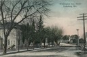
| Date: | 1934 |
|---|---|
| Description: | Southwest view of a covered bridge over Cedar Creek, with a man walking in the snow nearby. |
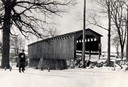
| Date: | 1966 |
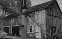
|---|---|
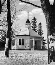
| Description: | Button factory at the Wetzel residence. At one time, bone buttons were manufactured in this building. A cat and a hand pump are in the foreground. |
If you didn't find the material you searched for, our Library Reference Staff can help.
Call our reference desk at 608-264-6535 or email us at: