 Filter: Creator Name of Brown, Charles E.
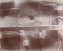
| Date: | 1885 |
|---|---|
| Description: | Elevated view of two men in the DuCharme house, later known as the Grignon house. |
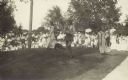
| Date: | 1914 |
|---|---|
| Description: | Ceremony for erecting tablets on the Observatory Hill Mounds performed by University of Wisconsin summer session students. |
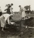
| Date: | 05 30 1931 |
|---|---|
| Description: | W.P. and Vivian Morgan, Grace Rollins and ? Mills excavate a burial mound in the Outlet group at the foot of Lake Monona. |
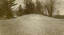
| Date: | 1913 |
|---|---|
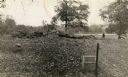
| Description: | One of the large burial mounds of the Outlet mound group on the former Hoyt property at the foot of Lake Monona. |

| Date: | |
|---|---|
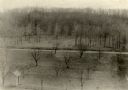
| Description: | An unusual burial mound in the Willow Drive mound group on the University of Wisconsin-Madison campus, prior to its excavation by Charles E. Brown. |
| Date: | 1930 |
|---|---|
| Description: | A linear burial mound and historic marker at the University Ridge mound group on the University of Wisconsin-Madison campus. The mound group was eventually... |

| Date: | 1915 |
|---|---|
| Description: | A row of conical burial mounds adjoins the Park and Pleasure Drive on the north shore of Lake Wingra (now Edgewood Drive, at the south edge of Edgewood Col... |

| Date: | 1910 |
|---|---|
| Description: | Exterior view of St. Andrews Episcopal Church. |
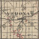
| Date: | 1924 |
|---|---|
| Description: | Map of Verona in Dane County from the Charles Brown Atlas. |
| Date: | |
|---|---|
| Description: | Elevated view of Man Mound outlined in chalk looking south. A road bisects the legs of the effigy mound. A small outbuilding can be seen at left in the for... |

| Date: | 04 12 1912 |
|---|---|
| Description: | Diagram of a bird effigy mound found in Frost's Woods, Blooming Grove Township. |

| Date: | 1930 |
|---|---|
| Description: | This map shows Indian trails through Wisconsin counties. The trail are in red ink. Lake Michigan, Green Bay, Lake Superior, and the Wisconsin River are lab... |

| Date: | 1916 |
|---|---|
| Description: | In 1916, it was estimated that 15,000 Indian mounds had formerly existed in Wisconsin. In the early 20th century, the Wisconsin Archaeological Society surv... |

| Date: | 1924 |
|---|---|
| Description: | This map of the Four Lakes region shows points of interest around the lakes, state trunk highways and other roads, railroads, and lakes and streams. Manusc... |

| Date: | 1913 |
|---|---|
| Description: | Ink and watercolor on tracing cloth. Shows parts of Green Lake, Princeton, and Brooklyn townships, Indian mound groups, Green Lake, and other significant b... |

| Date: | 1940 |
|---|---|
| Description: | This map of Aztalan is pencil and ink on paper. The map shows streets, local businesses, churches, houses, and the Crawfish River. The map reads: "Informat... |

| Date: | |
|---|---|
| Description: | View looking uphill towards three platform mounds. The numbers 1, 2, and 3 are written on the photograph in ink. Part of the way up the hill are a small sh... |
| Date: | |
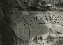
|---|---|
| Description: | Figures carved in stone at Twin Bluffs petroglyph site. |
| Date: | |
|---|---|
| Description: | A sketch of effigy mounds at Myrick Park. There is some scribbled-out writing at the top of the page. |
If you didn't find the material you searched for, our Library Reference Staff can help.
Call our reference desk at 608-264-6535 or email us at:
