Filter: Type of Photograph
Filter: Subject of landscape
Filter: Subject of landforms
Filter: Type of Photograph
Filter: Subject of landscape
Filter: Subject of landforms

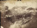
| Date: | 1958 |
|---|---|
| Description: | Aerial view of contour strip farming with the Obert Olstad farm in foreground. The Carl Backum farm is in the background. |
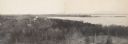
| Date: | 1945 |
|---|---|
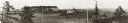
| Description: | Elevated view of Trempealeau County, south of Arcadia. |

| Date: | 12 01 1962 |
|---|---|
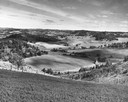
| Description: | A farm road between fields in late sunlight, looking towards Mounds Creek in the vicinity of CTH F. |
| Date: | 1902 |
|---|---|
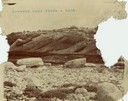
| Description: | A rock formation on Pyramid Lake's Rattlesnake Island. |
| Date: | |
|---|---|
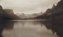
| Description: | The head of Upper St. Mary's Lake with the "Goddess of Liberty" glacier. |

| Date: | |
|---|---|
| Description: | Elevated view from bluff of a house in Cassville surrounded by bluffs, trees and farmland. Railroad tracks run between the crops and the trees, and the Mis... |
| Date: | |
|---|---|
| Description: | The Fort Smith Bluffs at the Big Horn Ditch on the Crow Reservation in northeast Wyoming. |
| Date: | |
|---|---|
| Description: | The Fort Smith Bluffs at the Big Horn Ditch on the Crow Reservation in northeast Wyoming. |

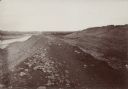
| Date: | 1902 |
|---|---|
| Description: | River with distant hills behind a town. An island is in the foreground. |
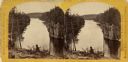
| Date: | 1880 |
|---|---|
| Description: | Stereograph of the Dalles rock formation with a two men in the foreground looking down at the Saint Croix River. On the left, one man stands leaning agains... |

| Date: | 11 19 1970 |
|---|---|
| Description: | Exterior view of the uniquely designed house of Byron Bloomfield at 1010 Edgehill Drive in Shorewood Hills, which is built into the side of a sharp slope. ... |

| Date: | 11 1951 |
|---|---|
| Description: | Aerial view of US Highway 14 southeast of La Crosse descending into Mormon Coulee. The original caption of the print, which is undated, describes the road ... |

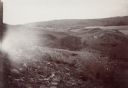
| Date: | 10 1905 |
|---|---|
| Description: | Elevated view from Reservoir Bluff to the east of the town. The bluffs of Iowa can be seen in the distance. |
| Date: | 08 03 1946 |
|---|---|
| Description: | View of the Wisconsin River from Cactus Bluff. |
| Date: | |
|---|---|
| Description: | The Battle of Chattanooga from the Milwaukee-based American Panoramic Company's cyclorama "The Storming of Missionary Ridge." |
| Date: | |
|---|---|
| Description: | Panoramic photograph from top of Bascom Hall facing northwest, showing Picnic Point on the University of Wisconsin campus. Washburn Observatory visible to ... |

| Date: | 03 31 1938 |
|---|---|
| Description: | Mississippi River from the bluffs and hills of western Wisconsin, looking south. |
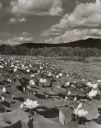
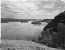
| Date: | 1957 |
|---|---|
| Description: | Lotus beds on Mississippi River in the foreground and middleground. Bluffs are in the background. |
If you didn't find the material you searched for, our Library Reference Staff can help.
Call our reference desk at 608-264-6535 or email us at: