 Filter: Type of Photograph
Filter: Subject of human settlements
Filter: Subject of islands
Filter: Type of Photograph
Filter: Subject of human settlements
Filter: Subject of islands

| Date: | |
|---|---|
| Description: | Elevated view from railing of immigrants boarding a ferry to depart Ellis Island. |
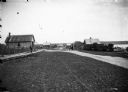
| Date: | 1910 |
|---|---|
| Description: | Looking down La Pointe's main street on Madeline Island. A man is walking on the board sidewalk on the left, and another person is driving a horse-drawn ve... |

| Date: | 1900 |
|---|---|
| Description: | View of La Pointe, Madeline Island, taken from the Mission Inn. |

| Date: | 05 16 1973 |
|---|---|
| Description: | Front view of the La Pointe Town Hall on Madeline Island. |

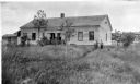
| Date: | 1900 |
|---|---|
| Description: | The house of Captain Angus on the shore of Lake Superior in La Pointe on Madeline Island sometime around 1900. The Angus family came to Madeline Island in ... |
| Date: | 1910 |
|---|---|
| Description: | George F. Thomas is holding a child and standing next to Edward F. Hansen in front of Treaty Hall in La Pointe on Madeline Island. |

| Date: | 1898 |
|---|---|
| Description: | Old Mission Residence at La Pointe, Madeline Island. |

| Date: | 1912 |
|---|---|
| Description: | Dilapidated Cedar Bark Lodge on Hermit Island, possibly during a period of renovation. |

| Date: | 07 10 1949 |
|---|---|
| Description: | Aerial view of Minocqua showing the surrounding lakes. |
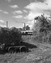
| Date: | 09 29 1963 |
|---|---|
| Description: | The Menasha Woodenware plant and water tower on Doty Island from across the Fox River canal, with a small railroad dolly in the foreground. |
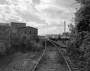
| Date: | 09 29 1963 |
|---|---|
| Description: | View down railroad tracks towards the railroad bridge, with industrial plants on Doty Island. |

| Date: | 1875 |
|---|---|
| Description: | Aerial view of Alma along Mississippi River, with bluffs along the horizon. |

| Date: | 1907 |
|---|---|
| Description: | Aerial view of the Mississippi River with log rafts. |

| Date: | 1902 |
|---|---|
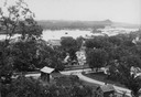
| Description: | River with distant hills behind a town. An island is in the foreground. |
| Date: | |
|---|---|
| Description: | View from hill looking down at houses and buildings at an intersection. Beyond are commercial buildings, the river, and the far shoreline. Hills are in the... |
| Date: | |
|---|---|
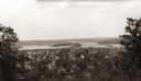
| Description: | Elevated view of the residential section of Eau Claire from Mount Tom. |

| Date: | 1956 |
|---|---|
| Description: | Aerial view looking northeast from a point over the east end of Middleton, showing the west end of Lake Mendota (right mid-ground). Fox Bluff juts into the... |

| Date: | 1929 |
|---|---|
| Description: | Ferryboat landing, with the boats providing service between Gills Rock and Washington Island. |
| Date: | |
|---|---|
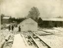
| Description: | Snow-covered buildings of a fishing village on Rock Island (also known as Pottawatomie Island). |

| Date: | 1955 |
|---|---|
| Description: | Aerial view of La Crosse, with Onalaska in the background. The highway is U.S. Highway 53 and the State Highway 35. |
If you didn't find the material you searched for, our Library Reference Staff can help.
Call our reference desk at 608-264-6535 or email us at: