 Filter: Categories of Wisconsin Historical Images
Filter: State of Wisconsin
Filter: Year of 1800-1899
Filter: Categories of Wisconsin Historical Images
Filter: State of Wisconsin
Filter: Year of 1800-1899
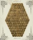
| Date: | 1861 |
|---|---|
| Description: | Composite of photographic portraits of the members of the Wisconsin State Assembly. |
| Date: | 1870 |
|---|---|
| Description: | View from shoreline over river towards the town. |
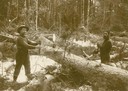
| Date: | 1880 |
|---|---|
| Description: | Two lumbermen posing with a two-man crosscut saw they are using on a fallen tree trunk, cutting the pine into manageable sizes for hauling. |
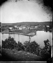
| Date: | 1875 |
|---|---|
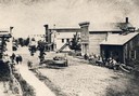
| Description: | A view of the village from a nearby bluff across a pond. Men, women and children, standing spaced apart, are posing in the field near the pond. |

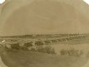
| Date: | 1886 |
|---|---|
| Description: | Bird's-eye view of Ashland, on the shores of Lake Superior, with insets of The Apostle Islands Chequamagon Bay & Ashland, and Distances from Ashland. |

| Date: | 1856 |
|---|---|
| Description: | This map show the surveyed southern part of state and includes "profile of the Milwaukee and Mississippi Rail Road." Counties are shown in pink, green, blu... |

| Date: | 1880 |
|---|---|
| Description: | Bird's-eye view of Jefferson on the Rock River. |

| Date: | 1871 |
|---|---|
| Description: | Drawing of the Peshtigo Fire, showing people seeking refuge in the Peshtigo River. |
| Date: | 1897 |
|---|---|
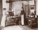
| Description: | Interior of the kitchen at 12 North Broom Street, the residence of James and Mary Ellen Nevin, showing Mrs. Nevin and her sister cooking. James Nevin was ... |

| Date: | 1842 |
|---|---|
| Description: | This hand-colored lithograph of the second Fort Howard, with Indians canoeing on the Fox River, shows the hospital built 1834-1835 outside the stockade on ... |

| Date: | 1886 |
|---|---|
| Description: | This map shows U.S. land offices, completed railroads, railroad land grant limits, lakes, rivers, and Indian reservations. Communities, lakes, and rivers a... |
| Date: | 1894 |
|---|---|
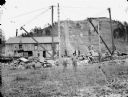
| Description: | Men loading rock from Saddle Mound quarry onto a St. Paul Railroad flat car. |

| Date: | 06 1837 |
|---|---|
| Description: | Lithograph based on a painting by Mrs. E.E. Bailey showing the Peck cabin, the first house in Madison. In addition to the cabin, the lithograph includes a ... |

| Date: | 1898 |
|---|---|
| Description: | Old Mission Residence at La Pointe, Madeline Island. |
| Date: | 1860 |
|---|---|
| Description: | Elevated view of Barstow Street looking north. View from the corner of Main Street, where the Eau Claire Book and Stationary Company later stood, looking n... |
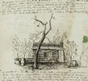
| Date: | 01 12 1844 |
|---|---|
| Description: | A pen and ink drawing of a log cabin, pork casks, and a washtub, contained in a letter written by Thomas Steel, Waukesha County farmer and physician, to hi... |
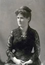
| Date: | 1885 |
|---|---|
| Description: | Formal studio portrait of Belle Case La Follette wearing a black lace dress. This photograph was taken about 1885, the year in which her husband, Robert M.... |

| Date: | 10 1829 |
|---|---|
| Description: | Fort Crawford as drawn by Seth Eastman. People are in a canoe in the river in the foreground. Across the river is the fort, other buildings around the fort... |
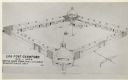
| Date: | 1817 |
|---|---|
| Description: | Elevated view of Old Fort Crawford. Caption reads: "Log Fort Crawford 1816-1829 Sketch Made From, Maj. S.H. Long's Description of 1817." |
If you didn't find the material you searched for, our Library Reference Staff can help.
Call our reference desk at 608-264-6535 or email us at:
