 Filter: Categories of Wisconsin Historical Images
Filter: State of Wisconsin
Filter: Year of 1800-1899
Filter: Type of Drawing
Filter: Categories of Wisconsin Historical Images
Filter: State of Wisconsin
Filter: Year of 1800-1899
Filter: Type of Drawing
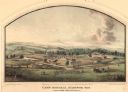
| Date: | 05 1864 |
|---|---|
| Description: | Lithograph of Camp Randall, where the majority of Wisconsin's soldiers were trained and mustered into the Union Army. This view, which was taken from Basc... |
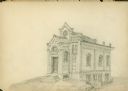
| Date: | 08 25 1885 |
|---|---|
| Description: | Gates of Heaven Synagogue. Designed by August Kutzbock. |
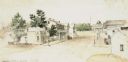
| Date: | 1851 |
|---|---|
| Description: | A watercolor view of Madison. Prominent on the left side of King Street is the Madison Hotel. |
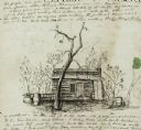
| Date: | 01 12 1844 |
|---|---|
| Description: | A pen and ink drawing of a log cabin, pork casks, and a washtub, contained in a letter written by Thomas Steel, Waukesha County farmer and physician, to hi... |

| Date: | 10 1829 |
|---|---|
| Description: | Fort Crawford as drawn by Seth Eastman. People are in a canoe in the river in the foreground. Across the river is the fort, other buildings around the fort... |
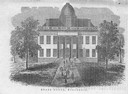
| Date: | 1856 |
|---|---|
| Description: | The Wisconsin State Capitol (the second State Capitol, the first in Madison). Illustration from the American Encyclopedia, Columbus, 1859. |
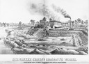
| Date: | 1880 |
|---|---|
| Description: | Lithograph of the Milwaukee Cement Company's Works at 154 West Water Street in Milwaukee. |

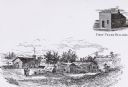
| Date: | 1834 |
|---|---|
| Description: | Peck-a-ton-oka (Pecatonica River) with Rodolf farm in the background. |
| Date: | 1833 |
|---|---|
| Description: | Illustration of the Solomon Juneau fur trading post at Milwaukee in 1833. |

| Date: | 07 1838 |
|---|---|
| Description: | A map diagram of Indian effigy mounds seven miles east of Blue Mounds in the Wisconsin Territory. |

| Date: | 1873 |
|---|---|
| Description: | Newspaper reproduction of an etching of the Milwaukee River. |
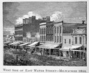
| Date: | 1844 |
|---|---|
| Description: | Illustration of the west side of East Water Street. |

| Date: | 1872 |
|---|---|
| Description: | The sidewheel packet, Red Wing, in the Mississippi River near Queen's Bluff below Trempealeau, Wisconsin. |

| Date: | 1855 |
|---|---|
| Description: | Detail from a lithograph vignette on a Map of the City of Madison of the third Wisconsin State Capitol, the first Capitol in Madison. |
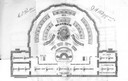
| Date: | 1874 |
|---|---|
| Description: | Seating chart for the Wisconsin Senate as it appeared in the 1874 Legislative Manual, commonly called the Wisconsin Blue Book. |
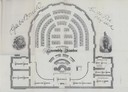
| Date: | 1874 |
|---|---|
| Description: | Seating chart for members of the Wisconsin Assembly as published in the 1874 Legislative Manual, the Wisconsin Blue Book. |
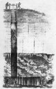
| Date: | 1844 |
|---|---|
| Description: | Cross section drawing of a Wisconsin lead mine. |
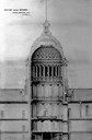
| Date: | 1857 |
|---|---|
| Description: | Section drawing of the rotunda of the third Wisconsin State Capitol (second in Madison) by Stephen V. Shipman. August Kutzbock and Samuel H. Donnel were th... |
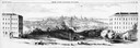
| Date: | 1858 |
|---|---|
| Description: | Panoramic sketch of State Street between North and South Halls on the University of Wisconsin-Madison campus. Published in Frank Leslie's Illustrate Newsp... |
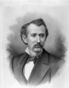
| Date: | 1880 |
|---|---|
| Description: | Charcoal portrait of George Baxter Burrows. A Wisconsin State Senator (1878-1882) and real estate broker, he willed his twelve-acre Lake Mendota frontage e... |
If you didn't find the material you searched for, our Library Reference Staff can help.
Call our reference desk at 608-264-6535 or email us at: