 Filter: Categories of Wisconsin Historical Images
Filter: State of Wisconsin
Filter: Subject of great lakes
Filter: Categories of Wisconsin Historical Images
Filter: State of Wisconsin
Filter: Subject of great lakes

| Date: | 07 1959 |
|---|---|
| Description: | Dickey Chapelle, photographer, on the same Milwaukee beach where she learned to swim as a young girl. She was covering "Operation Inland Seas" celebrating ... |

| Date: | 1823 |
|---|---|
| Description: | In 1823 U.S. Army major Stephen H. Long led an expedition of scientific, trade, and military investigation up the Mississippi River and the Red River of th... |
| Date: | 1910 |
|---|---|
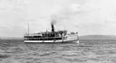
| Description: | View across water of the steamboat "Skater" cruising Lake Superior, with the Bayfield bluffs in the background. |
| Date: | 1904 |
|---|---|
| Description: | View from shoreline of the steamboat "Plowboy" approaching the Mission Dock at La Pointe. The Plowboy was the first steam ferry to go to Madeline Island. T... |
| Date: | 1900 |
|---|---|
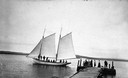
| Description: | Sailboat Lizzie W. at the Mission Dock. Captain Daniel Russell Angus, in the white sleeves, is at the tiller. The boat was named after Elizabeth Woo... |
| Date: | 1900 |
|---|---|
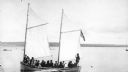
| Description: | Group of people on sailboat "Alpha" at dock on Madeline Island. Captain Daniel Angus is at the tiller. |

| Date: | 1900 |
|---|---|
| Description: | View of La Pointe, Madeline Island, taken from the Mission Inn. |

| Date: | 1900 |
|---|---|
| Description: | The house of Captain Angus on the shore of Lake Superior in La Pointe on Madeline Island sometime around 1900. The Angus family came to Madeline Island in ... |

| Date: | 1886 |
|---|---|
| Description: | Bird's-eye view of Ashland, on the shores of Lake Superior, with insets of The Apostle Islands Chequamagon Bay & Ashland, and Distances from Ashland. |
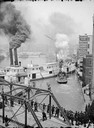
| Date: | |
|---|---|
| Description: | Elevated view of a Milwaukee River scene showing people watching several steamboats from a bridge. |
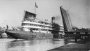
| Date: | 08 30 1906 |
|---|---|
| Description: | A screw passenger excursion vessel or whaleback, the Christopher Columbus, passing through the Broadway Bridge. |

| Date: | 1886 |
|---|---|
| Description: | Bird's-eye view of Bayfield, county seat of Bayfield County. On the lower left side is an inset for Bayfield and the Apostle Islands. |

| Date: | 1862 |
|---|---|
| Description: | Drawn the second year of the Civil War, this 1862 map of Milwaukee shows post offices, light houses, beacon lights, county buildings, elevator warehouses, ... |
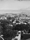
| Date: | |
|---|---|
| Description: | Elevated view south from Courthouse of rooftops, with harbor and bay in distance. |
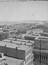
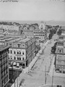
| Date: | |
|---|---|
| Description: | Milwaukee, towards South Point from Mitchell Block, E. Water Street and Michigan Street. Elevated view shows buildings and rooftops with bay and harbor in ... |
| Date: | |
|---|---|
| Description: | Looking east from Mitchell Block. Elevated view of buildings with the lake and a steamship in the distance. |
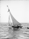
| Date: | |
|---|---|
| Description: | Several people are standing aboard a sailboat sailing in the harbor. A small boat is tied to the back of the sailboat. |
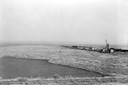
| Date: | 1936 |
|---|---|
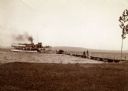
| Description: | Elevated view of logs tugged across Lake Superior to the harbor at Ashland. |

| Date: | 1883 |
|---|---|
| Description: | Bird's-eye map of Superior, county seat of Douglas County, on the shores of Lake Superior, with insets of points of interest. |

| Date: | 1913 |
|---|---|
| Description: | Bird's-eye map of Superior. "The New Steel Center." |
If you didn't find the material you searched for, our Library Reference Staff can help.
Call our reference desk at 608-264-6535 or email us at: