Filter: Categories of Wisconsin Historical Images
Filter: State of Wisconsin
Filter: Subject of cities and towns
Filter: Year of 1800-1899
Filter: Year of 1840-1849
Filter: Categories of Wisconsin Historical Images
Filter: State of Wisconsin
Filter: Subject of cities and towns
Filter: Year of 1800-1899
Filter: Year of 1840-1849

| Date: | 1848 |
|---|---|
| Description: | In 1849, northern Wisconsin was composed of huge sectional regions such as Chippewa, Portage, Brown and Crawford, whereas southern Wisconsin was constitute... |
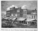
| Date: | 1844 |
|---|---|
| Description: | Illustration of the west side of East Water Street. |
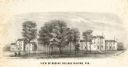
| Date: | 1848 |
|---|---|
| Description: | Sketch of the Madison Women's Seminary on the corner of Wisconsin Avenue and East Johnson. The Madison Female Academy was a 19th century school for girls w... |

| Date: | 1840 |
|---|---|
| Description: | A hand-drawn plat map of Mineral Point, Wisconsin showing street layout and location of buildings. |

| Date: | 1848 |
|---|---|
| Description: | Foldout map of a sketch of the town grid of Calumet. |
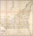
| Date: | 1849 |
|---|---|
| Description: | Foldout map of southern Wisconsin. |
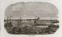
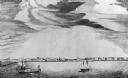
| Date: | 10 1844 |
|---|---|
| Description: | A variant of a wood engraving dated October, 1844. Incorporated as the villige of Southport in 1841 (so-named because it was the southern-most natural harb... |
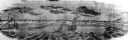
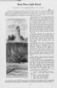
| Date: | 10 1844 |
|---|---|
| Description: | View from a pile-driver on the north pier of the community then known as Southport. The pier visible at left center, constructed between 1840-1842, was th... |
| Date: | 1842 |
|---|---|
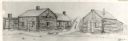
| Description: | Drawing of Front and State Streets, showing the first houses in La Crosse. |

| Date: | 1844 |
|---|---|
| Description: | Map of Wisconsin including Lakes Michigan and Superior. Inset includes "N.W. Part of Wiskonsan." |
| Date: | 1842 |
|---|---|
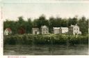
| Description: | View across the river towards several residences on the opposite shoreline. Caption reads: "Watertown in 1842." |
| Date: | 1841 |
|---|---|
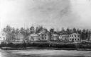
| Description: | View across the river towards several residences on the opposite shoreline. |

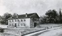
| Date: | 1847 |
|---|---|
| Description: | An artists rendition of the western view of the Thiensville mills from the local tavern. Caption reads: "West View of Thiensville Mills from the Tavern." |
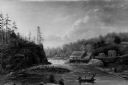
| Date: | 1845 |
|---|---|
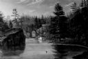
| Description: | View of the gorge at St. Croix with a boat and multiple figures visible in the background. |
| Date: | 1845 |
|---|---|
| Description: | View of Cheever's Mill, located on the St. Croix River. |

| Date: | 1848 |
|---|---|
| Description: | Immigrant map. |
If you didn't find the material you searched for, our Library Reference Staff can help.
Call our reference desk at 608-264-6535 or email us at: