 Filter: Categories of Wisconsin Historical Images
Filter: State of Wisconsin
Filter: Subject of cities and towns
Filter: Subject of foreign languages
Filter: Categories of Wisconsin Historical Images
Filter: State of Wisconsin
Filter: Subject of cities and towns
Filter: Subject of foreign languages

| Date: | 1849 |
|---|---|
| Description: | Published in Germany a year after Wisconsin entered statehood, this map shows prairies, swamps, lakes, mounds, limestone deposits, and lead and copper mine... |
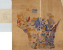
| Date: | 1890 |
|---|---|
| Description: | A hand-colored map of Wisconsin showing distribution ethnic groups based on the 1885 state census. The various nationalities are color-coded and include: I... |

| Date: | |
|---|---|
| Description: | Map shows roads, railroads, rivers, and improved farms. Includes text on lands for sale and exchange by B.W. Pulling, successor to Marshfield Land Company.... |

| Date: | 10 22 1966 |
|---|---|
| Description: | A young man and woman are seated at a booth and speaking to one or more people who have their backs to the camera. Behind them is a sign that reads: "le bo... |
If you didn't find the material you searched for, our Library Reference Staff can help.
Call our reference desk at 608-264-6535 or email us at: