 Filter: Categories of Wisconsin Historical Images
Filter: State of Virginia
Filter: Categories of Wisconsin Historical Images
Filter: State of Virginia
| Date: | |
|---|---|
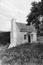
| Description: | Exterior of Ash Lawn, the official residence of James Monroe during the years 1799-1823. View features the overseer's cottage with an old stone chimney. |

| Date: | |
|---|---|
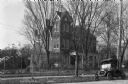
| Description: | Exterior view of York Hall, also known as Nelson House, built in 1730 in the Georgian style by "Scotch Tom" Nelson. In the foreground, the gardens can be ... |

| Date: | |
|---|---|
| Description: | Sketch of Mount Vernon, designed by George Washington in the Georgian style and built in 1757. Text on photograph reads, "Mount Vernon as It Appeared in Fo... |
| Date: | |
|---|---|
| Description: | Exterior of the residence of John B. Pinnel, an old gabled home on a residential street. A Ford automobile can be seen parked on the street. Published by T... |

| Date: | |
|---|---|
| Description: | Interior view of Mount Vernon, built in 1757 by George Washington. Curtis' Music Room houses a harpsichord, as well as other instruments. |
| Date: | |
|---|---|
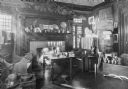
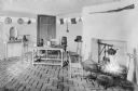
| Description: | Interior view of an early American home. The room features an elaborate fireplace, a violin, and paintings. |
| Date: | |
|---|---|
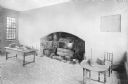
| Description: | Interior view of the Stratford Hall kitchen, featuring an extensive hearth. Built in 1725, Stratford Hall was the ancestral home of the family of Robert E... |

| Date: | |
|---|---|
| Description: | Interior of Robert E. Lee's study, preserved as he left it at Washington and Lee University. |
| Date: | |
|---|---|
| Description: | Interior view of the kitchen at Ash Lawn, built in 1799 by Thomas Jefferson. |
| Date: | |
|---|---|
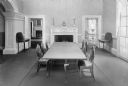
| Description: | Interior view of the dining room at Monticello, residence of Thomas Jefferson, built in 1772. A long dining table leads to a fireplace flanked by two door... |
| Date: | |
|---|---|
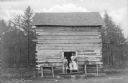
| Description: | View of a mother and three children standing on the front step of their mountain cabin. Published by the Virginia Store. |
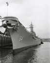
| Date: | 1957 |
|---|---|
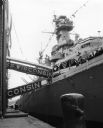
| Description: | View of the U.S.S. Wisconsin docked during decommissioning ceremonies in preparation for its final cruise. A number of sailors can be seen on deck. |

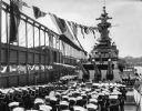
| Date: | 1957 |
|---|---|
| Description: | Ceremony beneath the guns on board the U.S.S. Wisconsin. A number of spectators and sailors are seated in the foreground, and uniformed sailors line... |

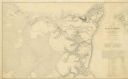
| Date: | 1861 |
|---|---|
| Description: | This map shows Manassas during the First Battle of Bull Run, in which the 2nd Wisconsin Infantry fought, and the Leesburg area, the site of the Battle of B... |
| Date: | 1957 |
|---|---|
| Description: | U.S.S. Wisconsin docked on the Hudson River at Norfolk, during decommissioning ceremonies. |
| Date: | 11 1957 |
|---|---|
| Description: | Uniformed sailors gathered on the deck of the U.S.S. Wisconsin during decommissioning ceremonies. |
| Date: | 1862 |
|---|---|
| Description: | This map illustrates the official plan for the siege of Yorktown, Virginia, and indicates the headquarters of Generals McClellan, Porter, Woodbury, and Hei... |

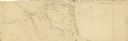
| Date: | 1862 |
|---|---|
| Description: | This map shows the region of southeastern Virginia which served as the setting for the Peninsular Campaign of 1862. A few battle sites are marked by crosse... |
| Date: | 1862 |
|---|---|
| Description: | This pen and ink drawing of the First Battle of Bull Run, JuIy 21st, 1861, was made by Charles K. Dean, adjutant with the 2nd Wisconsin Infantry. The 2nd W... |

| Date: | 1863 |
|---|---|
| Description: | This map shows roads, railroads, settlements, farms with owners' names, vegetation, streams, and fords in Culpeper County region during the Civil War. A ma... |
If you didn't find the material you searched for, our Library Reference Staff can help.
Call our reference desk at 608-264-6535 or email us at: