 Filter: Categories of Wisconsin Historical Images
Filter: State of Virginia
Filter: Creator Name of Unknown
Filter: Categories of Wisconsin Historical Images
Filter: State of Virginia
Filter: Creator Name of Unknown

| Date: | |
|---|---|
| Description: | A hand-drawn map of Indian boundary lines in southwest Virginia. It also includes the Duck River and the Elk River. |

| Date: | |
|---|---|
| Description: | Elevated view of a road and river winding through a mountainous landscape, seen from Waterlick White Hotel. Caption reads: "View from Hotel, Waterlick whit... |

| Date: | |
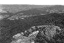
|---|---|
| Description: | Elevated view of a colony of residences in a mountain setting. |
| Date: | |
|---|---|
| Description: | Valley view from Skyline Drive. Four people on horseback look down upon the farmland of the valley from a rocky ledge. |

| Date: | |
|---|---|
| Description: | Elevated view of the Blue Ridge Terrace, a large hotel on a mountain overlooking the valley. Cars are parked near the road, and three men are gathered on t... |

| Date: | |
|---|---|
| Description: | Visitors walk along a path underneath a natural land bridge. |

| Date: | |
|---|---|
| Description: | Entrance to the tourist attraction of Lord Cornwallis Cave. The sign above the door reads, "Admission 10¢." Initials are inscribed in the dirt wall. |

| Date: | |
|---|---|
| Description: | View down hill toward the York River with small homes on its banks. Long piers stretch into the river. |
| Date: | |
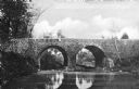
|---|---|
| Description: | View across water toward a stone bridge with two arches, built in the late nineteenth century, in the wooded setting of Bull Run Battlefield. |
| Date: | |
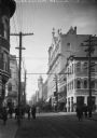
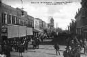
|---|---|
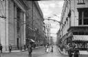
| Description: | View of a crowded intersection at Main Street. Pedestrians stand on the sidewalk and cross the street near carriages. On the left corner stands August Na... |
| Date: | |
|---|---|
| Description: | View of a busy downtown street. Pedestrians gather near Augusta National Bank on the street corner at right. |
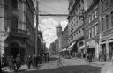
| Date: | |
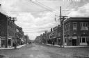
|---|---|
| Description: | Buildings, pedestrians on Granby Street at an intersection. Electrical street lighting arches above. Virginia National Bank, a Neo-Classical Revival buildi... |
| Date: | |
|---|---|
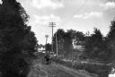
| Description: | A man steers a horse-drawn carriage down a sunken dirt road in a rural setting. Dwellings stand at right. |

| Date: | |
|---|---|
| Description: | View of an intersection of two dirt roads, East Market Street and Lafayette Street. A man, horseback, can be seen on the left, while two people walk past ... |
| Date: | |
|---|---|
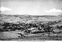
| Description: | Elevated view of the town and countryside, looking north. Published by Jackson's Pharmacy. |
| Date: | |
|---|---|
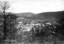
| Description: | Elevated view of town as seen from a hilly landscape. Published by The City Book Store. |
| Date: | |
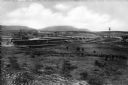
|---|---|
| Description: | View across an open field looking toward Bald Mountain Furniture Company and Angle Silk Mills Plant. |
| Date: | |
|---|---|
| Description: | View down Main Street. Men stand outside stores on either side of the street. |
| Date: | |
|---|---|
| Description: | View down Davis Street, a busy downtown area, looking East. Crowds stand on both sides of the road near storefronts. |

| Date: | |
|---|---|
| Description: | View down King Street featuring automobiles parked outside storefronts. |
If you didn't find the material you searched for, our Library Reference Staff can help.
Call our reference desk at 608-264-6535 or email us at: