 Filter: Categories of Wisconsin Historical Images
Filter: State of Vermont
Filter: Subject of transportation
Filter: Subject of botany
Filter: Categories of Wisconsin Historical Images
Filter: State of Vermont
Filter: Subject of transportation
Filter: Subject of botany
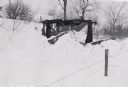
| Date: | 03 1941 |
|---|---|
| Description: | An International TD-14 crawler tractor (TracTracTor) with snowplow pushes through deep snow. Original caption reads: "Int. TD-14 Tractor equipped with fron... |
| Date: | |
|---|---|
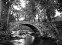
| Description: | View toward a stone bridge with arch over a stream bordered with flowers and trees on South Woodstock Road. |
| Date: | |
|---|---|
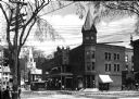
| Description: | View of Hotel Adnabrown from across the street including other surrounding buildings and a streetcar. Caption reads: "Hotel Adnabrown, Springfield, VT." |
| Date: | |
|---|---|
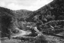
| Description: | View of a mountain pass named Dunville Notch. A group of farmhouses are located among trees and a dirt road. |
| Date: | |
|---|---|
| Description: | View of a mountain pass called Dunville Notch. A group of farmhouses are located among trees and a dirt road. Men gather near parked cars and a sign near t... |

| Date: | |
|---|---|
| Description: | A man is shoveling snow and a neighbor is standing in the background. Caption reads: "Main Street in Winter, St. Johnsbury, Vt." |

| Date: | |
|---|---|
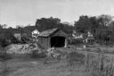
| Description: | View along sidewalk and road toward a wooden covered bridge. |

| Date: | |
|---|---|
| Description: | View up river toward a wooden covered bridge. A building is on the hill near the bridge on the right. |
| Date: | |
|---|---|
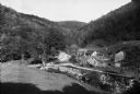
| Description: | Slightly elevated view across field toward a covered bridge, with town residential buildings in the background. |
| Date: | |
|---|---|
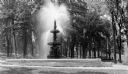
| Description: | View of a figural fountain in Taylor Park, given to the town by John Gregory Smith in 1887. |

| Date: | |
|---|---|
| Description: | View of the center village green featuring parked cars and a monument. A church steeple rises above trees. |

| Date: | |
|---|---|
| Description: | View of a covered bridge, looking toward South Lincoln. Dwellings are in the distance, and mountains are in the background. |
| Date: | |
|---|---|
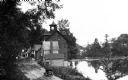
| Description: | Elevated view of a riverside road with waterfront buildings. One of the buildings has a belltower. |

| Date: | |
|---|---|
| Description: | Banks and dwellings stand along one side of the Savings Bank Block. Published by Photo Department of The Old Corner Drug Store. |

| Date: | |
|---|---|
| Description: | View of Dorset Inn, established in 1796, and its flagstone cottage walk. |

| Date: | |
|---|---|
| Description: | View down Ethan Allen highway. To the right stands "The House by the Side of the Road." |
| Date: | |
|---|---|
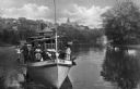
| Description: | View of an outing party on board the pleasure boat, 'Victor.' Published by The Rexall Drug Store. |

| Date: | 1795 |
|---|---|
| Description: | Map of Vermont showing counties, townships, cities, roads, mountains, lakes, and rivers. A forest and waterfall scene decorates the title cartouche in the ... |
If you didn't find the material you searched for, our Library Reference Staff can help.
Call our reference desk at 608-264-6535 or email us at:

