Filter: Categories of Wisconsin Historical Images
Filter: State of Vermont
Filter: Subject of cities and towns
Filter: Categories of Wisconsin Historical Images
Filter: State of Vermont
Filter: Subject of cities and towns
| Date: | |
|---|---|
| Description: | View of the Springfield Savings Bank block from a park across the street including large trees. Caption reads: "Savings Bank Block, Springfield, VT." |
| Date: | |
|---|---|
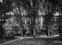
| Description: | View of Hotel Adnabrown from across the street including other surrounding buildings and a streetcar. Caption reads: "Hotel Adnabrown, Springfield, VT." |

| Date: | |
|---|---|
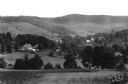
| Description: | Elevated view of the city from Mount Equinox. Located in the center of the city is First Congregational Church, established in 1784. Caption reads: "East f... |

| Date: | |
|---|---|
| Description: | View down a dirt road leading to Mount Equinox in the background. A church is in the valley near the road, and a cemetery is located on the other side of... |

| Date: | |
|---|---|
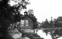
| Description: | View of a dam and river with a town along the shoreline in the background. |
| Date: | |
|---|---|
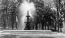
| Description: | View of a figural fountain in Taylor Park, given to the town by John Gregory Smith in 1887. |
| Date: | |
|---|---|
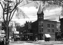
| Description: | View of the Ethan Allen House, built in 1787 and named after Vermont's founder. The courthouse can be seen to its right, originally built in 1836, burned i... |
| Date: | |
|---|---|
| Description: | Elevated view of a riverside road with waterfront buildings. One of the buildings has a belltower. |

| Date: | |
|---|---|
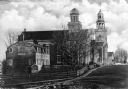
| Description: | Elevated city view from an overlooking mountain. A church and cemetery stand among dwellings. |

| Date: | |
|---|---|
| Description: | Banks and dwellings stand along one side of the Savings Bank Block. Published by Photo Department of The Old Corner Drug Store. |

| Date: | 1795 |
|---|---|
| Description: | Map of Vermont showing counties, townships, cities, roads, mountains, lakes, and rivers. A forest and waterfall scene decorates the title cartouche in the ... |

| Date: | 1950 |
|---|---|
| Description: | Subject: "Land Clearing — TD-14A." Where Taken: "NE." Information with photograph reads: "TD-14A owned by Winoski Soil Conservation District, Montpelier, V... |
If you didn't find the material you searched for, our Library Reference Staff can help.
Call our reference desk at 608-264-6535 or email us at: