 Filter: Categories of Wisconsin Historical Images
Filter: State of Tennessee
Filter: Year of 1800-1899
Filter: Categories of Wisconsin Historical Images
Filter: State of Tennessee
Filter: Year of 1800-1899

| Date: | 1863 |
|---|---|
| Description: | This colored map of the Battle of Chattanooga depicts the positions of the Union and Confederate troops before the battle and on each day of the battle. Al... |

| Date: | 1863 |
|---|---|
| Description: | This map of the Battle of Chattanooga depicts roads, railroads, drainage, vegetation, relief, and the names of residents in the outlying areas. Fourteen Wi... |

| Date: | 1864 |
|---|---|
| Description: | This map depicts the positions of Union forces, in blue, and Confederate forces, in red, at the end of 1863 after the cessation of the Knoxville Campaign. ... |

| Date: | 1866 |
|---|---|
| Description: | This detailed map shows the positions of the armies of the Ohio and Tennessee, Confederate lines, headquarters, "regimental camps at the date of the battle... |
| Date: | 10 14 1887 |
|---|---|
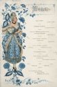
| Description: | One-page menu for the visit of President Grover Cleveland to Memphis, with a woman with an upswept hairstyle and a choker, wearing a low-necked Delftware-p... |
| Date: | 10 14 1887 |
|---|---|
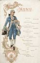
| Description: | One-page menu for the visit of President Grover Cleveland to Memphis, with a man in a powdered wig wearing a waistcoat with wide, decorated cuffs, ruffled... |

| Date: | 1800 |
|---|---|
| Description: | Map of the new state of Tennessee. It shows borders, numerous boundary lines (particularly Native American boundaries), towns (European and Native American... |
| Date: | 1861 |
|---|---|
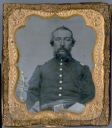
| Description: | A tintype portrait of Francis Wilson of the Dodgeville Guards, 12th Wisconsin Volunteer Infantry, Company C. The buttons and epaulets on his uniform, as we... |
If you didn't find the material you searched for, our Library Reference Staff can help.
Call our reference desk at 608-264-6535 or email us at: