 Filter: Categories of Wisconsin Historical Images
Filter: State of Tennessee
Filter: Subject of roads
Filter: Categories of Wisconsin Historical Images
Filter: State of Tennessee
Filter: Subject of roads

| Date: | 1954 |
|---|---|
| Description: | An aerial view of the International Harvester Memphis Works in Memphis, Tennessee, with a view of the surrounding neighborhood and Loosahatchie River. The ... |
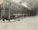
| Date: | 1930 |
|---|---|
| Description: | Men (mostly likely employees), plows, cane mills and an evaporator are lined up on a Main Street sidewalk outside the Chattanooga Plow Works. |
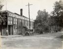
| Date: | 1919 |
|---|---|
| Description: | Exterior view from street of the Chattanooga Plow Works. Lettering on the building reads "Chattanooga Plow Company." The photograph was likely taken around... |
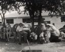
| Date: | |
|---|---|
| Description: | Meeting in Tennessee during CIO period, on a street. |

| Date: | |
|---|---|
| Description: | Two elderly women walking on a sidewalk next to a storefront. |
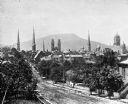
| Date: | |
|---|---|
| Description: | Elevated view of a densely settled residential area with the steeples of five churches vaulting high above the rooftops. In the background is a formation o... |
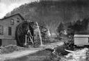
| Date: | |
|---|---|
| Description: | View toward a mill with a large water wheel and spring branch, near King Solomon's Cave. A man is posed standing next to the middle of the water wheel. Cap... |
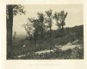
| Date: | 1866 |
|---|---|
| Description: | A road runs up the side of Mission Ridge with several trees. Trees and shrubs are in the foreground, overlooking a valley. Mountains are in the distance. |
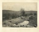
| Date: | 1866 |
|---|---|
| Description: | A rocky ridge with bushes and scrub atop Mission Ridge is in the foreground. Orchard Knob is in the distance. The valley where the fighting took place is i... |

| Date: | 1864 |
|---|---|
| Description: | View down to valley of Union soldiers posing on the roof of a log building. A log bridge crosses a stream, and many trees are on the hillsides. Plate 05... |
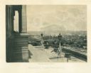
| Date: | 1864 |
|---|---|
| Description: | View down capitol building steps, where cannons sit on a landing, and statues decorate two lampposts. The city spreads out far below. Plate 03 |
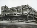
| Date: | 1925 |
|---|---|
| Description: | Exterior view of the International Harvester Company Nashville branch warehouses and offices. Several trucks are parked on a loading dock along the side of... |

| Date: | 1862 |
|---|---|
| Description: | This map of the Battle of Shiloh shows relief by hachures, vegetation, drainage, houses, fields, fences, mills, and roads and is color coded to show the mo... |

| Date: | 1863 |
|---|---|
| Description: | This map is a hand-colored, pen and ink, drawing by Ole R. Dahl of Co. B, 15 Wisconsin Infantry shows the battlefield at Stones River, depicting roads, str... |

| Date: | 1863 |
|---|---|
| Description: | This colored map of the Battle of Chattanooga depicts the positions of the Union and Confederate troops before the battle and on each day of the battle. Al... |

| Date: | 1863 |
|---|---|
| Description: | This map of the Battle of Chattanooga depicts roads, railroads, drainage, vegetation, relief, and the names of residents in the outlying areas. Fourteen Wi... |

| Date: | 1866 |
|---|---|
| Description: | This detailed map shows the positions of the armies of the Ohio and Tennessee, Confederate lines, headquarters, "regimental camps at the date of the battle... |

| Date: | 1795 |
|---|---|
| Description: | Map of the new state of Tennessee. It shows borders, numerous boundary lines (particularly Native American boundaries), towns (European and Native American... |

| Date: | 1796 |
|---|---|
| Description: | Map of the new state of Tennessee. It shows borders, numerous boundary lines (particularly Native American boundaries), towns (European and Native American... |

| Date: | 1800 |
|---|---|
| Description: | Map of the new state of Tennessee. It shows borders, numerous boundary lines (particularly Native American boundaries), towns (European and Native American... |
If you didn't find the material you searched for, our Library Reference Staff can help.
Call our reference desk at 608-264-6535 or email us at: