 Filter: Categories of Wisconsin Historical Images
Filter: State of Tennessee
Filter: Subject of lakes
Filter: Categories of Wisconsin Historical Images
Filter: State of Tennessee
Filter: Subject of lakes
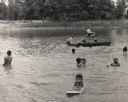
| Date: | |
|---|---|
| Description: | Children swimming in a lake as part of Highlander Folk School's Koinonia Children's Camp. |

| Date: | |
|---|---|
| Description: | Myles Horton, co-founder of the Highlander Folk School, walking near lake. On the patio of the Horton house. |
| Date: | |
|---|---|
| Description: | Mine, Mill & Smelters Union reading by a lake at Highlander Folk School. Will Thomas, second on the right, smoking a pipe. |

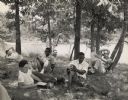
| Date: | |
|---|---|
| Description: | Farmers Union School gathering at Highlander. A.A. Liveright smoking a pipe and holding a camera, left; Paul Bennett, right. |
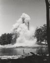
| Date: | |
|---|---|
| Description: | Detonated dynamite effecting the spillway to Highlander Lake. |

| Date: | |
|---|---|
| Description: | Farmers Union workshop outdoors near water at Highlander Folk School. B.R. Brazeal is on the extreme left. May Justus, Highlander's Secretary-Treasurer, a... |

| Date: | |
|---|---|
| Description: | Civil rights group meeting in field at Highlander Lake. Fifth from the left, Charlotte Meacham, American Friends Service Committee, former Highlander stud... |

| Date: | |
|---|---|
| Description: | Russell Bull, regional Packinghouse Workers director, fishing in Highlander Lake. He has just caught a largemouth bass. |

| Date: | |
|---|---|
| Description: | Youth project and children's campers swimming in Highlander Lake |
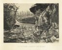
| Date: | 1866 |
|---|---|
| Description: | Cliffs along Lu-la Lake. A waterfall is in the background. Plate 15 |

| Date: | 1795 |
|---|---|
| Description: | Map of the new state of Tennessee. It shows borders, numerous boundary lines (particularly Native American boundaries), towns (European and Native American... |

| Date: | 1796 |
|---|---|
| Description: | Map of the new state of Tennessee. It shows borders, numerous boundary lines (particularly Native American boundaries), towns (European and Native American... |

| Date: | 1800 |
|---|---|
| Description: | Map of the new state of Tennessee. It shows borders, numerous boundary lines (particularly Native American boundaries), towns (European and Native American... |
If you didn't find the material you searched for, our Library Reference Staff can help.
Call our reference desk at 608-264-6535 or email us at:
