 Filter: Categories of Wisconsin Historical Images
Filter: State of Tennessee
Filter: Subject of battlefields
Filter: Categories of Wisconsin Historical Images
Filter: State of Tennessee
Filter: Subject of battlefields
| Date: | 02 15 1862 |
|---|---|
| Description: | "The 2nd and 7th Iowa and the 52nd Indiana headed by General Smith storming up the rebel works at Fort Donelson causing its surrender to General Grant the ... |

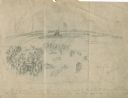
| Date: | 1862 |
|---|---|
| Description: | Preliminary sketch of a battlefield with trees and human outlines. |

| Date: | 1864 |
|---|---|
| Description: | View across the Tennessee River toward the city and Cameron Hill, showing the military bridge and some Union Army installations put up following the occupa... |
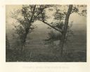
| Date: | 1866 |
|---|---|
| Description: | Location of Sherman's attack at Chattanooga. There is a road, trees and shrubs in the foreground, overlooking a valley. Mountains are in the distance. P... |
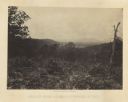
| Date: | 1866 |
|---|---|
| Description: | View from Mission Ridge of the valley floor where fighting took place. Plate 10 |

| Date: | 1862 |
|---|---|
| Description: | This map of the Battle of Shiloh shows relief by hachures, vegetation, drainage, houses, fields, fences, mills, and roads and is color coded to show the mo... |

| Date: | 1863 |
|---|---|
| Description: | This map is a hand-colored, pen and ink, drawing by Ole R. Dahl of Co. B, 15 Wisconsin Infantry shows the battlefield at Stones River, depicting roads, str... |

| Date: | 1863 |
|---|---|
| Description: | This colored map of the Battle of Chattanooga depicts the positions of the Union and Confederate troops before the battle and on each day of the battle. Al... |

| Date: | 1863 |
|---|---|
| Description: | This map of the Battle of Chattanooga depicts roads, railroads, drainage, vegetation, relief, and the names of residents in the outlying areas. Fourteen Wi... |

| Date: | 1864 |
|---|---|
| Description: | This map depicts the positions of Union forces, in blue, and Confederate forces, in red, at the end of 1863 after the cessation of the Knoxville Campaign. ... |

| Date: | 1866 |
|---|---|
| Description: | This detailed map shows the positions of the armies of the Ohio and Tennessee, Confederate lines, headquarters, "regimental camps at the date of the battle... |
If you didn't find the material you searched for, our Library Reference Staff can help.
Call our reference desk at 608-264-6535 or email us at: