 Filter: Categories of Wisconsin Historical Images
Filter: State of Rhode Island
Filter: Subject of intellectual life
Filter: Categories of Wisconsin Historical Images
Filter: State of Rhode Island
Filter: Subject of intellectual life
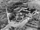
| Date: | 1950 |
|---|---|
| Description: | An aerial view of the monastery, showing a complex of buildings, roads, and the surrounding tree-covered property. A walled garden is between the entrance ... |

| Date: | 1799 |
|---|---|
| Description: | Map of Rhode Island showing counties, townships, cities, roads, mountains, swamps, islands, reefs, lakes and rivers. Several of the bigger cities include s... |

| Date: | 1795 |
|---|---|
| Description: | Map of Rhode Island showing counties, townships, cities, roads, mountains, swamps, islands, reefs, lakes and rivers. Several of the bigger cities include s... |
If you didn't find the material you searched for, our Library Reference Staff can help.
Call our reference desk at 608-264-6535 or email us at: