 Filter: Categories of Wisconsin Historical Images
Filter: State of Pennsylvania
Filter: Subject of mountains
Filter: Categories of Wisconsin Historical Images
Filter: State of Pennsylvania
Filter: Subject of mountains

| Date: | |
|---|---|
| Description: | View from inside doorway of a hangar toward a man near an airplane at the landing field of an aerial mail station. Hills or mountains are in the distance. |
| Date: | |
|---|---|
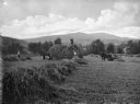
| Description: | Agricultural workers are loading hay onto a wagon pulled by two horses in the vicinity of Carbondale or Elk Hill. A man sits in a horse-drawn carriage near... |
| Date: | |
|---|---|
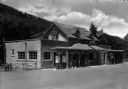
| Description: | The Molino Service Station and grill on former U.S. Route 120, now Pennsylvania Route 61. Signs on the building advertise "Bar-B-Q," "Lunch," and "Ice Crea... |
| Date: | |
|---|---|
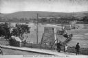
| Description: | Slightly elevated view of several people overlooking a bridge under construction. Caption reads: "Building The New Bridge, Berwick, PA." |
| Date: | |
|---|---|
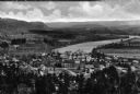
| Description: | Elevated view of country town showing large. There are wooden buildings alongside the Delaware River which curves through fields and patches of woods in th... |
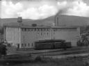
| Date: | |
|---|---|
| Description: | Elevated view of a factory in Youngsville, with a railroad car and railroad tracks in front of it. In the background is a hill or mountain. |

| Date: | 1944 |
|---|---|
| Description: | International KS-11 truck and semi-trailer shown traveling the highway leading out of Altoona. Original caption reads: "In traveling these mountainous road... |

| Date: | 1863 |
|---|---|
| Description: | Stereograph of Round Top Mountain, near the site of the Gettysburg battlefield. A man sits on a stump, shading his eyes with his hand, gazing at the mounta... |

| Date: | 1756 |
|---|---|
| Description: | Map of Pennsylvania, showing cities, towns, roads, trading paths, portages, forts, mountains, swamps, waterfalls, lakes, and rivers. The map further includ... |

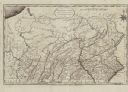
| Date: | 1792 |
|---|---|
| Description: | Map of Pennsylvania showing counties, cities, towns, forges and mills, houses, roads, portages, mountains, lakes, and rivers. The map also shows donation a... |
| Date: | 1795 |
|---|---|
| Description: | Map of Pennsylvania showing counties, cities, roads, quarries, roads, mountains, lakes and rivers. |
If you didn't find the material you searched for, our Library Reference Staff can help.
Call our reference desk at 608-264-6535 or email us at: