Filter: Categories of Wisconsin Historical Images
Filter: State of Ohio
Filter: Subject of rivers
Filter: Subject of human settlements
Filter: Categories of Wisconsin Historical Images
Filter: State of Ohio
Filter: Subject of rivers
Filter: Subject of human settlements

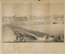
| Date: | 1790 |
|---|---|
| Description: | Map of the region surrounding Dayton, Ohio showing rivers and other settlements, with a table of distances from Cincinnati to Dayton and to points outside ... |
| Date: | 09 22 1862 |
|---|---|
| Description: | The 22nd Regiment Wisconsin Volunteers under the command of Colonel William L. Utley, crossing the pontoon bridge at Cincinnati. |

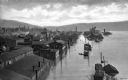
| Date: | |
|---|---|
| Description: | Elevated view over the Ohio River of a boat landing with a bridge in the background. |
| Date: | |
|---|---|
| Description: | Elevated view of Second Street and surrounding area during a flood of the Ohio River. Some buildings are submerged up to their roof lines and the street re... |

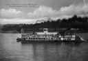
| Date: | 1910 |
|---|---|
| Description: | Passengers board the excursion boat "Crescent No. 1" as others look on from bridges. There is a large building in the background on the left, and a long, w... |
| Date: | 1920 |
|---|---|
| Description: | Bridge over the Chagrin river and falls in town with surrounding buildings and an advertisement for the May company. |
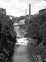
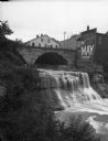
| Date: | 1910 |
|---|---|
| Description: | Elevated view of small falls on the Cayahoga River in a gorge with waterfront buildings. |
| Date: | |
|---|---|
| Description: | Elevated view of the steamboat "Keystone State" in the Ohio River near Portsmouth. The text "Keystone State" is painted on the rear of the ship, but is par... |
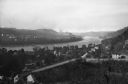
| Date: | 1910 |
|---|---|
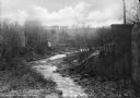
| Description: | Elevated and distant southerly view of the Ohio river winding through a town. A bridge crosses the river in the foreground, and trees and houses are locate... |

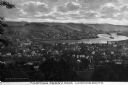
| Date: | 1910 |
|---|---|
| Description: | Elevated view of the First Presbyterian church and two mansions. The Mahoning river and a park is in the foreground, and other parts of the town stretch in... |
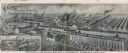
| Date: | 1901 |
|---|---|
| Description: | Lithographed poster depicting an elevated view of the Warder, Bushnell, and Glessner factory and surrounding area. Text in the upper left corner reads, "Ch... |
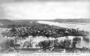
| Date: | |
|---|---|
| Description: | Elevated view of the Ohio River and surrounding towns. |
| Date: | 01 1907 |
|---|---|
| Description: | Elevated city view during a January flood. Caption reads: "View of Gallipolis, Ohio, in January Flood of 1907." |

| Date: | 1833 |
|---|---|
| Description: | Increase Lapham's plan for the canal terminus on Portsmouth Point at the confluence of the Scioto and Ohio Rivers. |
If you didn't find the material you searched for, our Library Reference Staff can help.
Call our reference desk at 608-264-6535 or email us at: