 Filter: Categories of Wisconsin Historical Images
Filter: State of North Carolina
Filter: Subject of cities and towns
Filter: Categories of Wisconsin Historical Images
Filter: State of North Carolina
Filter: Subject of cities and towns
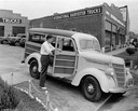
| Date: | 09 20 1938 |
|---|---|
| Description: | Young man inspecting the interior of an International Model D-2 station wagon ("woody") outside an International Harvester dealership. |
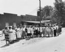
| Date: | 1969 |
|---|---|
| Description: | View from across road of picket line of striking employees of the Neuhoff Company who were members of the Amalgamated Meat Packers and Butcher workmen unio... |
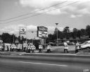
| Date: | 08 1957 |
|---|---|
| Description: | Women workers on strike against the Holly Farms Poultry Company, posed outside for a "solidarity" picture. Dorothy Johnson, wearing the third picket sign f... |
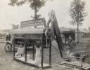
| Date: | 1920 |
|---|---|
| Description: | A Meadows stone burr grain mill powered by an International Harvester engine grinding wheat into flour at what appears to be an outdoor fair or exhibition.... |

| Date: | |
|---|---|
| Description: | Exterior of the North Carolina State Capitol, constructed in 1840 in the Greek Revival style. A woman walks past a statue toward the building's entrance. |
| Date: | |
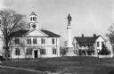
|---|---|
| Description: | View of Chowan County Courthouse, built in 1767 by architect John Hawks. The Georgian building features a central cupola and clock tower. A Confederate mon... |
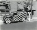
| Date: | 09 20 1938 |
|---|---|
| Description: | View from across street of a man loading a bag of laundry into the back of an International D-2 panel truck painted in a checkerboard pattern. The truck is... |
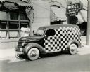
| Date: | 09 20 1938 |
|---|---|
| Description: | An International Model D-2 truck owned by Model Laundry Company parked outside the business' storefront. The truck is painted in a checkerboard pattern and... |

| Date: | 1865 |
|---|---|
| Description: | This map illustrates the lines of defense established by Confederate troops, under the command of General Joseph E. Johnston, at Raleigh, North Carolina, i... |

| Date: | 1779 |
|---|---|
| Description: | Map of North Carolina showing counties, cities, towns, chapels, courthouses, Quaker meeting houses, forts, mountains, swamps, inlets, lakes, and rivers. A ... |

| Date: | 1795 |
|---|---|
| Description: | Map of North Carolina showing counties, cities, towns, courthouses, forts, roads, mountains, swamps, inlets, waterfalls, lakes, and rivers. A dotted square... |
If you didn't find the material you searched for, our Library Reference Staff can help.
Call our reference desk at 608-264-6535 or email us at: