 Filter: Categories of Wisconsin Historical Images
Filter: State of New York
Filter: Subject of waterfalls
Filter: Categories of Wisconsin Historical Images
Filter: State of New York
Filter: Subject of waterfalls
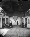
| Date: | 1877 |
|---|---|
| Description: | View towards men and women sitting and standing, beneath the lower deck of a suspension bridge (train uses upper deck). There are two booths (for tolls or ... |
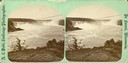
| Date: | 1877 |
|---|---|
| Description: | Stereograph of "Two different views of the Falls from Canada side," from the series "Niagara Falls and Suspension Bridge" as mentioned in Dahl's 1877 "Cata... |
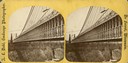
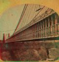
| Date: | 1877 |
|---|---|
| Description: | An A.L. Dahl photograph, one of "Two different side views of the Suspension Bridge," from the series "Niagara Falls and Suspension Bridge" as mentioned in ... |
| Date: | 1877 |
|---|---|
| Description: | An A.L. Dahl photograph, one of "Two different views of the Falls from Canada side," from the series "Niagara Falls and Suspension Bridge" as mentioned in ... |
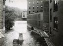
| Date: | 1912 |
|---|---|
| Description: | Water pouring over a dam near International Harvester's Osborne Works. The factory was later known as "Auburn Works." |
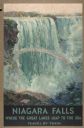
| Date: | 1934 |
|---|---|
| Description: | An original lithograph promoting Niagara Falls as the place "Where the Great Lakes Leap to the Sea, Travel by Train." Featuring the artist Fredric C. Madan... |
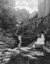
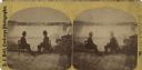
| Date: | |
|---|---|
| Description: | A portrait of two women and one man who are sitting on rocks near the waterfall. There is an old mill above them on the right. |

| Date: | 1877 |
|---|---|
| Description: | Stereograph of "Two different views of the Falls from Canada side," from the series "Niagara Falls and Suspension Bridge" as mentioned in Dahl's 1877 "Cata... |
| Date: | 1877 |
|---|---|
| Description: | An A.L. Dahl photograph, one of "Two different side views of the Suspension Bridge," from the series "Niagara Falls and Suspension Bridge" as mentioned in ... |

| Date: | 1877 |
|---|---|
| Description: | An A.L. Dahl photograph, one of "Two different views of the Falls from Canada side," from the series "Niagara Falls and Suspension Bridge" as mentioned in ... |

| Date: | 1760 |
|---|---|
| Description: | Map showing upstate New York, Lake Ontario, and the St. Lawrence River during the last, decisive battle of the French and Indian War. The main map shows a ... |

| Date: | 1778 |
|---|---|
| Description: | Map of the land between Fort Ticonderoga and Albany. It shows cities, forts, mills, roads, mountains, swamps, waterfalls, lakes, and rivers. A few annotati... |
If you didn't find the material you searched for, our Library Reference Staff can help.
Call our reference desk at 608-264-6535 or email us at: