 Filter: Categories of Wisconsin Historical Images
Filter: State of New York
Filter: Subject of ponds
Filter: Categories of Wisconsin Historical Images
Filter: State of New York
Filter: Subject of ponds

| Date: | |
|---|---|
| Description: | A peaceful view of a pond and mill, featuring a small dog sitting in a boat, which rests on the shore. |

| Date: | |
|---|---|
| Description: | View across Scudder's Pond, featuring a fence framed by trees in the foreground, and a house on the opposite shoreline in the background. |

| Date: | |
|---|---|
| Description: | View of a dirt bicycle path running alongside a small pond, with scattered trees. |

| Date: | |
|---|---|
| Description: | Two men in suits crossing a rickety floating bridge on Squash Pond near Hotel Glennmore. |

| Date: | 1904 |
|---|---|
| Description: | A view of the mill and pond landscape of Sleepy Hollow. |

| Date: | |
|---|---|
| Description: | A view of an ornate gazebo set in a pond. The pond has a fountain spray and tree-lined paved paths of the park are visible in the background while a flowe... |

| Date: | |
|---|---|
| Description: | A view of an ornate gazebo strung with lights and set in a pond. The pond has a fountain spray and is surrounded by grass and trees. Published by bson [?... |
| Date: | |
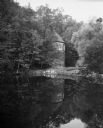
|---|---|
| Description: | Small round stone building in the woods reflected in a pond or lake. |

| Date: | |
|---|---|
| Description: | Water garden at the New York Botanical Gardens featuring palms and water lilies along a conservatory walkway. |

| Date: | |
|---|---|
| Description: | Elevated view of a formal garden, a fountain and a pond bordered by woods. |
| Date: | |
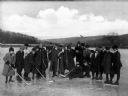
|---|---|
| Description: | A group of boys from Eymard Seminary wearing ice skates and winter dress while holding hockey sticks. |

| Date: | 02 1777 |
|---|---|
| Description: | Map depicting the campaigns of October and November 1776, in Manhattan, Westchester, and part of New Jersey, published only a few months after the conclusi... |

| Date: | 1789 |
|---|---|
| Description: | Map of New York City showing ward boundaries, ferries, streets, roads, swamps, ponds, and rivers. The properties of Lispinard, Byards, Jones, Rutgers, and ... |

| Date: | 1776 |
|---|---|
| Description: | Fairly detailed map of New York City and parts of Long Island. It shows streets, roads, wharves, ferries, ship yards, Fort George and the battery, public b... |
If you didn't find the material you searched for, our Library Reference Staff can help.
Call our reference desk at 608-264-6535 or email us at: