Filter: Categories of Wisconsin Historical Images
Filter: State of New York
Filter: Subject of ferries
Filter: Categories of Wisconsin Historical Images
Filter: State of New York
Filter: Subject of ferries
| Date: | 1969 |
|---|---|
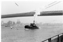
| Description: | The Island's Edge, Williamsburg Bridge, East River. |
| Date: | |
|---|---|
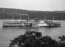
| Description: | Elevated view over tree tops of the "Albany" steamship on the Hudson River near West Point. The large ship features three decks full of passengers, several... |

| Date: | |
|---|---|
| Description: | View across water toward the "Hendrick Hudson" excursion boat near New York City. Many passengers are on the large excursion boat's three decks. The boat a... |
| Date: | |
|---|---|
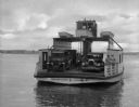
| Description: | View of an automobile ferry boat traveling to or from Shelter Island Heights. Several men are on the ferry, along with three automobiles. "Shelter Island O... |

| Date: | |
|---|---|
| Description: | View of the ferry carrying passengers across the Allegheny River near Salamanca, New York's Island Park. Many passengers are on board the ferry, and in the... |

| Date: | 1968 |
|---|---|
| Description: | View of Manhattan from the Staten Island Ferry, with a couple standing in the foreground. The woman is wearing a leopard print coat, and seagulls wheel in ... |

| Date: | 1968 |
|---|---|
| Description: | Two passengers stand over a bench and look out of the ferry towards the water. The developed shoreline and a pier with a seagull perched on top can be see... |

| Date: | 11 1781 |
|---|---|
| Description: | Map of New York, Staten Island, and Long Island, showing the placements of forts, and the movement of troops in 1776. The map also includes towns, cities, ... |

| Date: | 1789 |
|---|---|
| Description: | Map of New York City showing ward boundaries, ferries, streets, roads, swamps, ponds, and rivers. The properties of Lispinard, Byards, Jones, Rutgers, and ... |

| Date: | 1776 |
|---|---|
| Description: | Fairly detailed map of New York City and parts of Long Island. It shows streets, roads, wharves, ferries, ship yards, Fort George and the battery, public b... |
If you didn't find the material you searched for, our Library Reference Staff can help.
Call our reference desk at 608-264-6535 or email us at: