 Filter: Categories of Wisconsin Historical Images
Filter: State of Mississippi
Filter: Subject of land
Filter: Categories of Wisconsin Historical Images
Filter: State of Mississippi
Filter: Subject of land
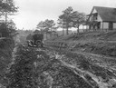
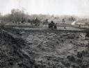
| Date: | 1915 |
|---|---|
| Description: | Man driving an automobile down a muddy dirt road. Caption on back reads: "Grading road with surfacing." The photograph was taken for International Harveste... |
| Date: | 10 03 1862 |
|---|---|
| Description: | "Combined Confederate attack upon [Batteries] Robinette and Davis the attack on Battery Robinette being defeated and that on Davis resulting in the defeat ... |
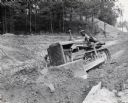
| Date: | 1938 |
|---|---|
| Description: | A man operates an International T-40 TracTracTor (crawler tractor). Original caption reads: "International T-40 TracTracTor equipped with bullgrader and us... |

| Date: | 1947 |
|---|---|
| Description: | Three-quarter side view of a man driving an International KB-5 Pulpwood Special heavily loaded with logs through a wooded area. The truck was owned by John... |

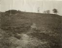
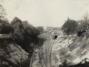
| Date: | 1900 |
|---|---|
| Description: | Railroad redoubt seen from the north showing the slope where General Grant's column charged on May 22, 1863, during the siege of Vicksburg. |

| Date: | 1902 |
|---|---|
| Description: | Cave in a hillside occupied by the Lewis family from May 18 to July 4, 1863, during the Civil War siege of Vicksburg. Hundreds of other caves in the vicin... |
| Date: | 1902 |
|---|---|
| Description: | Confederate "Fort Hill" on the south side of Jackson Road where the Confederate entrenchments run southward. The Siege of Vicksburg lasted from May to July... |

| Date: | 1910 |
|---|---|
| Description: | Surrender Monument, where Generals Grant and Pemberton met to arrange terms for the surrender of Vicksburg, July 3, 1863. General Pemberton surrendered 31,... |
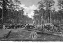
| Date: | |
|---|---|
| Description: | A view of a logging scene. White and African American workers are posing for a group portrait. Oxen are pulling logs, and other large logs are piled on bot... |
| Date: | 03 18 1915 |
|---|---|
| Description: | View of an abandoned cotton field along the side of a dirt road. A farmhouse and farm buildings are in the distance. |
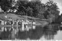
| Date: | 1900 |
|---|---|
| Description: | View across water towards an outdoor baptism at McBrayer's Pond. A group of adults and children are gathered at the water's edge, some of them holding para... |

| Date: | 04 1902 |
|---|---|
| Description: | Confederate veterans at the Vicksburg Surrender Monument, on the occasion of decorating Union soldiers' graves. |
| Date: | 11 30 1915 |
|---|---|
| Description: | Elevated view towards a train depot located in a valley. |
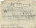
| Date: | 1863 |
|---|---|
| Description: | This map depicts the opening battles in the Union campaign against Vicksburg, Mississippi, in May 1863. Noted are the Battle of Port Gibson, May 1, 1863, t... |

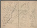
| Date: | 1876 |
|---|---|
| Description: | This map of the Battle of Iuka depicts the May 19, 1862, positions of the Union forces in blue and Confederate in red. Indicated on the map are roads, the ... |

| Date: | 1964 |
|---|---|
| Description: | A simple map of the Mississippi Project. There are symbols at the bottom marking locations for: Voter Registration, Freedom School, Community Center and Pr... |

| Date: | 1960 |
|---|---|
| Description: | A hand-drawn map showing the "Negro Percentage of Each County's Population" in Mississippi. |
If you didn't find the material you searched for, our Library Reference Staff can help.
Call our reference desk at 608-264-6535 or email us at: